Resources

Fighting fire with data: the national emergency response information system

Webinar RecordingSlide DeckQ&A one-pager

The U.S. Fire Administration (USFA) is leading a national effort to develop and launch a new interoperable fire information and innovative analytics platform known as the National Emergency Response Information System (NERIS).

Join experts from USFA, Fire Safety Research Institute, and DHS Science & Technology to learn how NERIS will empower the fire and emergency services community with robust data analytics and geospatial tools.

In this webinar, attendees will gain a basic understanding of the new National Emergency Response Information System (NERIS), which will be launching in 2024.

Webinar Objectives:

  • Learn about the core features and functionality that will be available through NERIS.
  • Gain insights on how you’ll be able to use the system and apply NERIS-derived data and analytics to support GIS-based risk assessments, risk reduction efforts, mitigation strategies, and planning efforts.
  • Develop a plan for onboarding your department or organization onto NERIS and ways to implement NERIS capabilities organization-wide.
  • Engage directly with the NERIS team, and contribute ideas on enhancing the platform.

Target Audience:

  • Public Safety Leaders
  • First Responders

Speakers:

  • Rebecca Harned, Advisor, U.S. Fire Administration
  • David Alexander, Senior Science Advisor, DHS Science & Technology Directorate
  • (ret.) Chief Tom Jenkins, Senior Advisor, Fire Safety Research Institute
  • Craig Weinschenk, Principal Investigator, Fire Safety Research Institute

Additional Resources:

Locating Justice – The Power of GIS in Law Enforcement

Webinar RecordingSlide DeckQ&A one-pager

The use of GIS in law enforcement has moved beyond traditional crime analytics. From field applications, to tactical and strategic dashboards, managing sensitive data, and empowering line-level personnel with geospatial tools, GIS is changing how law enforcement operates.

In this webinar, attendees will learn about some of these uses in California and Maryland.

Webinar Objectives:

  • Promote best practices and improve collaboration across law enforcement.
  • Share efforts on how local law enforcement agencies are solving real-world problems.
  • Raise awareness of the tools available to most agencies.

Target Audience:

  • Law Enforcement Personnel
  • Crime Analysts
  • GIS Technologists & Support Staff

Speakers:

  • Shelby Roberson – GIS Manager, Montgomery County Police Department
  • Matt Harris – Crime Analyst, Santa Rose Police Department

Additional Resources:

MATERIALS AVAILABLE – InSPIRE 2023

Day 1Day 2About InSPIRE


Back to Top

Day 1
Welcome & Keynote Presentations
Sessions


Back to Top

Day 2
Welcome & Agenda Overview
Sessions


Back to Top

About InSPIRE 2023

NAPSG Foundation hosted the 2023 Innovation Summit for Preparedness & Resilience (InSPIRE 2023) on November 16th & 17th at the Dubois Center in Charlotte, North Carolina. The focus of InSPIRE 2023 was The Community in Action and highlighted the exceptional work and real-world impacts of the Public Safety Community. This year, we had 150+ public safety leaders, first responders, GIS professionals, and technologists from 38 states and 6 countries!

InSPIRE is the nation’s leading summit dedicated to advancing the use of geospatial technology for preparedness and resilience. This annual, in-person event brings together public safety leaders, first responders, GIS professionals, and technologists to explore practical solutions to the most prominent public safety policy and technology challenges being implemented across the nation. Programming is designed for federal, tribal, territorial, state, and local governments and is crafted to foster innovation to build a culture of preparedness, strengthen communities, and increase resilience nationwide.

Save the Date for InSPIRE 2024 — details coming soon! 

The NAPSG Team

From State to National: Damage Assessment Collection & Coordination

PrepTech Talks logo

Webinar Recording
Slide Deck
Q&A One-Pager

Damage assessments are a crucial process for jurisdictions to perform correctly after an incident. When done efficiently, they can provide evidence of the severity of the disaster and justify the need for federal assistance to help the community recover. They can also identify the areas that need the most assistance and support the proper allocation of resources. A well-planned and tested technical approach can ensure that assessments are conducted promptly.

On June 5th, 2023, NAPSG Foundation hosted the PrepTech Talk “From State to National: Damage Assessment Collection and Coordination.” In this webinar, you will learn about the coordinated approach the state of Oregon is implementing to ensure locals have access and training on using preconfigured GIS tools. Also, you will hear how FEMA validates and leverages this data, and the tools and data standards they provide to assist your jurisdiction in streamlining the damage assessment process.  

Webinar Objectives
  • Promote best practices and improve collaboration across all levels of government in the damage assessment process to improve outcomes for survivors. 
  • Share efforts to support locals and standardize damage assessment process across the state of Oregon, and aid other jurisdictions looking to develop a similar coordinated approach.
  • Raise awareness of tools available from FEMA, how FEMA currently consumes data from states, and goals for streamlining data collection and sharing in the future.

Speakers
  • Daniel Stoelb, GIS Program CoordinatorOregon Department of Emergency Management
  • Melodie O’Hanlon, Project Manager, FACT system, FEMA 
Seminar Resources
Innovations in Multi-Modal AI Technology for Emergency Management

PrepTech Talks logo

Webinar Recording
Slide Deck
Q&A One-Pager

On March 2, 2023, NAPSG Foundation hosted the PrepTech Talk “Innovations in Multi-Modal AI Technology for Emergency Management.” In this feature presentation, you will hear from Joel Tetreault, Sr. Director of AI for Dataminr, as he discusses how multi-modal fusion AI is assisting emergency management and shares examples where real-time information, identified and disseminated by AI, was able to help the emergency management agencies.

Seminar Objectives
  • Learn about multi-modal AI technology for emergency management.
  • Hear real world examples of how this technology has helped emergency managers during crises.
  • Understand best practices as new technology continues to revolutionize emergency management.

Speaker
  • Joel Tetreault, Senior Director of Research, Dataminr, Inc.
Seminar Resources
The Future is Now: Building Robust, Effective, and Sustainable Data Practices and Partnerships for the Next Generation of the HIFLD Community

PrepTech Talks logo

Webinar Recording
Slide Deck


On November 9th, 2022, NAPSG Foundation hosted the PrepTech Talk “The Future is Now: Building Robust, Effective, and Sustainable Data Practices and Partnerships for the Next Generation of the HIFLD Community.” In this webinar, participants learned about the exciting changes that are coming to the Homeland Infrastructure Foundation Level Data (HIFLD) Program.

HIFLD is a Community: Data made available through HIFLD is generated by Federal agencies, National labs, and commercial vendors. It is then reviewed by NGA for quality, completeness, metadata, etc., and then published by HIFLD on a quarterly basis. The HIFLD user community is 4000+ strong; governance is maintained through the HIFLD Subcommittee, which consists of federal agency representatives who serve as voting members.

To explore what’s new and updated for HIFLD, please visit https://hifld-geoplatform.opendata.arcgis.com/.

Webinar Objective
  • Engage with new and longtime members of the HIFLD Community to share program vision, priorities, and desired impact.

Speakers
  • Julie Sokol, HIFLD Subcommittee Co-Chair and GeoData and HIFLD Program Manager under the DHS Geospatial Management Office (GMO)
  • Constantin Tudan, HIFLD Subcommittee Co-Chair and Deputy Chief Data Officer under the Office of the Chief Technology Officer (OCTO) at DHS Cybersecurity and Infrastructure Security Agency (CISA)
Webinar Resources
Hacking for Homeland Security: Lean Innovation Training

PrepTech Talks logo

Webinar Recording
Slide Deck


On July 27th, 2022, NAPSG Foundation hosted the presentation “Hacking for Homeland Security: Lean Innovation Training.” Lean Innovation Training offers participants the toolsets to build a business and technical case for continual improvement challenges within government agencies. This training event helped participants define an operating system to identify problems, create appropriate solutions, and integrate the solutions into their organization.

Click on the recording below to learn how you can leverage Hacking for Homeland Security (H4HS) to build solution business cases for senior leaders in your organization.

Speakers
  • Vanessa Zabala Msc., Program Manager for Hacking for Homeland Security (H4HS), BMNT
  • Bull Holland, Director of H4X Training, BMNT
Seminar Resources
Official Release: Public Safety Location-Based Services Challenges Report

June 20th, 2022

The National Alliance for Public Safety GIS (NAPSG) Foundation is pleased to release the Public Safety Location-Based Services Challenges Report. The report documents the ongoing gaps and challenges of indoor mapping, tracking, and navigation for first responders.

The Public Safety Location-Based Services Challenges Report is a culmination of the work conducted by the i-Axis Team, and it summarizes findings from working group meetings and events, in-person and virtual conferences, multiple outreach surveys, and open comments through the i-Axis Community Hub.

Download the report! The report is available for download here.


NAPSG Foundation would like to thank the National Institute of Standards and Technology (NIST), Public Safety Communications Research Division, for their continued support of the
i-Axis project.

Disaster Ready GIS – Small Shop, Big Impact

PrepTech Talks logo

Webinar Recording
Slide Deck
Q&A One-Pager

On May 12th, 2022, NAPSG Foundation hosted the PrepTech Talk “Disaster Ready GIS – Small Shop, Big Impact.” In this feature presentation from Anne Arundel County, MD, you will learn about their response to the series of tornadoes that spawned across the region from the remnants of Hurricane Ida, and gain insights into innovative data sources and the value of building your geospatial network.

Seminar Objectives
  • Gain insight into practical products that you can configure to support first responders, decision-makers, and the public during an incident.
  • Discover resources available to State, Local, Tribal, and Territorial (SLTT) communities that you should integrate into workflows before a disaster strikes.
  • Learn steps that your shop, big or small, can take to build your network and capabilities.

Speakers
  • Joanie Appell, AICP, GISP, Anne Arundel County Fire Department
  • Richard Butgereit, Geospatial Insurance Consortium
  • John Desmarais, Civil Air Patrol, U.S. Air Force Auxiliary
Seminar Resources
Official Release: Version 2 of the i-Axis Best Practices Guide to Indoor Mapping, Tracking, and Navigation

May 16th, 2022

The National Alliance for Public Safety GIS (NAPSG) Foundation is pleased to release the
second version of the i-Axis Best Practices Guide to Indoor Mapping, Tracking, and Navigation. The purpose of this guide is to accelerate the adoption of Location-Based Services (LBS) by providing first responders with a resource to start or improve their current programs.

This version has been developed over the past year with
input from the LBS First Responders Working Group, a group of experts made up of representatives from law enforcement, fire, emergency medical services, emergency management, the private sector, and the military. Additional input has been solicited from researchers working on LBS and vendors who provide these technologies.

Download the Best Practices Guide! The guide is available for download here.

NAPSG Foundation has set up an i-Axis Community Hub. This hub provides documentation on LBS Working Group meetings, sandboxes to test out mapping, tracking, and navigation applications, and additional resources for agencies looking to implement a program.

Funding for this Guide was provided under financial assistance award No. 70NANB19H006, from the National Institute of Standards and Technology (NIST) Public Safety Communications Research (PSCR) Division’s Public Safety Innovation Accelerator Program (PSIAP).

The Technology Innovation for Preparedness and Operations Flood Hub is now live!

April 4, 2022

The National Alliance for Public Safety GIS (NAPSG) Foundation is pleased to announce that the Technology Innovation for Preparedness and Operations Flood Hub is now live. This hub provides curated resources that have been developed since 2019 and includes guidelines, applications, geospatial resources, best practices, and success stories from the community.

Access the Hub today! For full access to the flood hub, please click here.


Funding for the hub was provided by the Department of Homeland Security’s Science and Technology Directorate under agreement 70RSAT20C00000008.

US&R Maps, Apps, and Collabs: A 2021 Year-in-Review

PrepTech Talks logo

Webinar Recording
View StoryMap


On March 10th, 2022, NAPSG Foundation hosted the virtual PrepTech Talk “US&R Maps, Apps, and Collabs: A 2021 Year-in-Review.” Tune in for this round table discussion on how Urban Search and Rescue (US&R) teams leveraged the Search and Rescue Common Operating Platform (SARCOP) during multiple incidents in 2021.

Webinar Objectives
  • Gain insight into how preplanning and exercises can set the stage for a successful response.
  • Review the geospatial response to the Champlain Tower collapse in Surfside (FL), Hurricane Ida, and the Quad-State Tornados.
  • Learn about the integration of drone/sUAS imagery into US&R workflows.

Speakers
  • Jared Doke, Program Manager, NAPSG Foundation
  • Justin Adams, President of CRASAR
  • Katie Breland, Training Manager for TEEX TX-TF1 & Plans Team Manager for TX-TF1
  • Lexi Passaro, Plans Team Manager PA-TF1
  • Mike Parker, Assistant Chief, West Metro Fire & Plans Team Manager CO-TF1
  • Zico Orozco, Tech Info Specialist, MO-TF1
  • Santiago Ramos, Lt. for City of Miami Fire Rescue and Plans Team Manager for FL-TF2
  • Brandy Paternoster, Lt. for Miami Dade Fire Rescue, Plans Team Manager FL-TF1
Webinar Resources
Official Release: National Flood Preparedness Guideline Update

March 28, 2022

Now Available!

Access the Guideline

The National Alliance for Public Safety GIS (NAPSG) Foundation is pleased to release the updated version of the National Flood Preparedness Guideline (NFPG). Building upon the work done in 2017, the updated guideline was
developed by a group of first responders, technologists, GIS professionals, flood modeling experts, the private sector, academia, and other subject matter experts in flooding.

Through three virtual workshops, the group identified key data needs for the first responder community during flood disasters, as well as challenges facing the community. Major challenges such as the overwhelming amount of reliable, timely, and accessible information, the sophistication of flood modeling, and pace of technology innovation were identified and form the basis for the rest of the NFPG.

The NFPG was developed with a diverse audience in mind. Key takeaways and chapter
introductions summarize the technical content for those unfamiliar with the concepts, and
spotlights and toolkits throughout the document highlight real-world implementation
examples that are considered best practices.

How can you use the guideline?

The NFPG strives to address a complex problem and requires significant effort to implement. It should be viewed as a goal for agencies to strive for. To be successful, agencies and
jurisdictions should still:

  • Identify roles and responsibilities for flood preparedness and response, including within organizations (laterally) and with subordinate or senior organizations (vertically).
  • Form a collaborative team to address concepts within the NFPG, with an emphasis on dynamic and flexible team members who can adapt to a range of disasters.

What’s next?

The NFPG development is the start, not the end, of creating an interoperable system of geospatial tools and technology to aid in flood preparedness and response. You are
encouraged to leverage the resources identified in the NFPG to bolster your program, and
continually exercise, refine, and share your lessons learned with the larger community.

Challenges remain in aiding local jurisdictions with flood preparedness and response. The tools and processes outlined in the NFPG require formalized standard operating procedures, agency support, and daily use.

Download the National Flood Preparedness Guideline! The guideline is available for download here (https://www.napsgfoundation.org/wp-content/uploads/2022/03/National-Flood-Preparedness-Guideline-2022.pdf).


Funding for this guideline was provided by the Department of Homeland Security’s Science and Technology Directorate under agreement 70RSAT20C00000008.

NAPSG Foundation: Delivering Solutions Today, Innovating for Tomorrow

PrepTech Talks logo

Webinar Recording
Slide Deck


On December 9th, 2021, NAPSG Foundation hosted the last PrepTech Talk of the year, “NAPSG Foundation: Delivering Solutions Today, Innovating for Tomorrow.” In this webinar, NAPSG’s staff discussed the refocused mission statement in addition to recently available resources and opportunities for the public safety community.

Seminar Objectives
  • Gain insight into how NAPSG Foundation has listened and responded to the public safety community in 2021.
  • Discover resources and guidance available to you and learn how to utilize these products within your organization.
  • Connect with opportunities to share your perspective and shape ongoing efforts that benefit the public safety community.
  • Learn about how NAPSG Foundation’s refocused mission will shape our path going forward.

Click on the recording below to hear all about what we have been up to in 2021 and how you can get more involved in 2022!

Speakers
  • Peter O’Rourke, Executive Director
  • Tari Martin, Director
  • Kevin Kay, Director
  • Jared Doke, Program Manager
  • Charlotte Abel, Strategic Manager
Seminar Resources
GIS for Search & Rescue: A Caribbean & International Perspective

Webinar Recording
Slide deck 1: Trinidad & Tobago Fire
Slide deck 2: INSARAG

On August 4th, 2021, NAPSG Foundation hosted our first Member Innovations webinar. In this webinar, titled “GIS for Search and Rescue: A Caribbean and International Perspective,” Trinidad and Tobago Fire Service and International Search and Rescue Advisory Group (INSARAG) team members discussed innovative strategies for the integration of geographic information systems (GIS). This webinar was led by NAPSG Community Member Kevin Noel, a professional firefighter and GIS pioneer.

Webinar Topics
  • The implementation of GIS for Search and Rescue in Trinidad & Tobago.
  • GIS resources and best practices available and relevant to the international community.
  • Pioneering and championing the use and integration of GIS in public safety.
Speakers
Seminar Resources
Innovations in Resource Management & Mutual Aid Technology

PrepTech Talks logo

Webinar Recording
Slide Deck
Q&A One-Pager

On July 22nd, 2021, NAPSG Foundation hosted the virtual PrepTech Talk titled “Innovations in Resource Management & Mutual Aid Technology.” In this webinar, industry leaders discussed the latest developments in nationally available technology tools and standards that increase resource management preparedness and improve efficiencies in managing incidents.

Seminar Objectives

Resource management is the cornerstone of preparing for and responding to incidents that require mutual aid among agencies and jurisdictions. Currently, the adoption and use of standardized resource management policies, practices, and technology vary greatly at the local level nationwide.

From this webinar, participants will:

  • Gain insights into the current state of the nation in implementing policy, standards, and technology for resource typing, inventorying, and management.
  • Find out what’s new in version 3.0 of the Implementation Guide on Information Sharing Standards and how you can use the guide in informing your agency’s technology selection and acquisition process to ensure interoperability and seamless information sharing.
  • Learn about FEMA’s National Resource Hub and how to gain access and start using the suite of resource management tools.
  • Gain insight into how the National Resource Hub can connect and share data with your other incident management systems, situational awareness apps, and other 3rd party systems today and in the future.
  • Learn what is in development to improve existing and innovations in new resource management and mutual aid technology tools and systems.
Speakers
  • Harmon Rowland, Section Chief, FEMA National Integration Center
  • Elysa Jones, Chair, OASIS Emergency Management Technical Committee
  • Rebecca Harned, Vice President, 4 Arrows Consulting, Inc. 
  • Charlotte Abel, Strategic Manager, NAPSG Foundation
Seminar Resources
Resource Management Maturity Study Report Available!

Resource Management Maturity Study

Call to Action!

Contribute to this study and help inform national guidance by sharing your agency’s resource management practices.

Access the Questionnaire

Resource management is the cornerstone of preparing for and responding to incidents that require mutual aid among agencies and jurisdictions. Currently, the adoption and use of standardized resource management policies, practices, and technology vary greatly at the local level nationwide. To unify efforts and improve resource management for daily operations and larger-scale incidents, we need first to understand how agencies are managing their resources today.

NAPSG Foundation responded to this need by launching a study to form a baseline understanding of the extent of implementation of resource typing, inventorying, and management across the nation. Findings from this effort will help inform future guidance and technology investments that are part of the National Incident Management System (NIMS) and National Qualifications System (NQS) and various resource management and mutual aid systems commonly in use today.

The report from this study is now available to help inform NIMS and other locally-driven national guidance and programs. Provided below are the key questions that guided this study:

  • What is our status in implementing NIMS resource management principles and concepts?
  • What is our status in implementing NQS?
  • What challenges do we experience in implementing NIMS and NQS?
  • What technology tools are we using today to support implementation, and what technology capabilities are needed to advance our resource management practices?

View the full report! https://arcg.is/0TzC5K
Access Report
This effort was made possible through a partnership with the U.S. Department of Homeland Security’s Science and Technology Directorate (Agreement #70RSAT18CB0000041).

COVID-19 Tech & GIS After Action Report & Improvement Plan

February 25, 2021

NAPSG Foundation, URISA, and NSGIC logos

Goal: Enhance the public health and emergency management system by fostering data-driven decision making

Primary Objective: Identify and document capability gaps and lessons learned in information sharing and the use of GIS and data-driven technology in response to and recovery from COVID-19

The National Alliance for Public Safety GIS (NAPSG) Foundation, the National States Geographic Information Council (NSGIC), and the Urban Regional Information Systems Association (URISA) are pleased to announce the release of the COVID-19 Tech & GIS After Action Report & Improvement Plan.

The AAR and improvement plan represent a significant effort to document emerging trends and areas for improvement in technology-enabling emergency management and public health’s response to a pandemic. The AAR process applied a largely empirical research methodology that ensured data was collected and assessed using standard practices for ensuring the quality and consistency of both quantitative and qualitative data.

Note: All of the data collected and analyzed for this AAR reflects only the first six (6) months of the response. Additional insights and trends may be gained through expanded AAR data collection efforts as the pandemic continues to unfold.

screenshot of COVID-19 Tech & GIS After-Action Report & Improvement Plan


This effort is made possible through support from the U.S. Department of Homeland Security’s Science and Technology Directorate (Agreement #70RSAT18CB0000041).

Official Release: i-Axis Best Practices Guide to Indoor Mapping, Tracking, and Navigation

February 22, 2021

The National Alliance for Public Safety GIS (NAPSG) Foundation is pleased to release the first version of the i-Axis Best Practices Guide to Indoor Mapping, Tracking, and Navigation. The purpose of this guide is to accelerate the adoption of Location-Based Services (LBS) by providing first responders with a resource to start or improve their current programs.

The Best Practices Guide has been developed over the past year and a half with input from the LBS First Responders Working Group, a group of experts made up of representatives from law enforcement, fire, emergency medical services, emergency management, the private sector, and the military. Additional input has been solicited from researchers working on LBS and vendors who provide these technologies.

Download the Best Practices Guide! The guide is available for download here.

As these technologies continue to evolve, so will the guide. Comments are always welcome on the current version, and version 2 is already in progress! To provide recommendations on current best practices or submit a new best practice, click here.

NAPSG Foundation has set up an i-Axis Community Hub. This hub provides documentation on LBS Working Group meetings, sandboxes to test out mapping, tracking, and navigation applications, and additional resources for agencies looking to implement a program.

Funding for this Guide was provided under financial assistance award No. 70NANB19H006, from the National Institute of Standards and Technology (NIST) Public Safety Communications Research (PSCR) Division’s Public Safety Innovation Accelerator Program (PSIAP).

Open for Comment: i-Axis Best Practices Guide to Indoor Mapping, Tracking, and Navigation

December 1, 2020

Mapping, tracking, and navigating indoors is one of the greatest challenges facing first responder safety today. The built environment is growing both in volume and complexity – increasing the potential frequency of public safety response to 911 calls made within structures where locating victims poses unique challenges. Today more than ever, first responders need solutions to provide better situational awareness indoors, equipping them with necessary capabilities to operate effectively while maximizing responder and citizen safety.

NAPSG Foundation is responding to this need by partnering with the National Institute of Standards and Technology (NIST), Public Safety Communications Research Division (PSCR) to develop a Best Practices Guide to Indoor Mapping, Tracking, and Navigation. This guide seeks to accelerate the adoption of Location-Based Services (LBS) by providing first responders with a resource to start or improve their current programs.

The Best Practices Guide has been developed over the past year with input from the LBS First Responders Working Group, a group of experts made up of representatives from law enforcement, fire, emergency medical services, emergency management, the private sector, and the military. Additional input has been solicited from researchers working on LBS and vendors who provide these technologies.

To view the first version (V1) of the Best Practices Guide, click here.

You have the opportunity to comment on V1 of the Best Practices Guide and help fellow public safety agencies navigate these emerging technologies.

To provide recommendations on current best practices, or to submit a new best practice, click here.

Additionally, NAPSG Foundation has set up an i-Axis Community Hub. This hub provides documentation on LBS Working Group meetings, sandboxes to test out mapping, tracking, and navigation applications, and additional resources for agencies looking to implement a program.

If you have questions about the Best Practices Guide or the i-Axis Community Hub, please send an email to Kevin Kay with NAPSG Foundation at kkay@publicsafetygis.org.

Decrypting Risk, Resilience, Social Vulnerability Data & Indices

PrepTech Talks logo

Webinar Recording
Slide Deck
Guidance on Indices

On November 17th, 2020, NAPSG Foundation hosted the virtual PrepTech Talk titled “Decrypting Risk, Resilience, Social Vulnerability Data & Indices.” In this training, participants learned about various risk, resilience, and social vulnerability indices that are available today to assist in choosing the right data for the right product.

Seminar Objectives

Understanding a community’s risk, resilience, and vulnerability are vital pieces to effective disaster management and resource planning. Since there are various indices currently available today that aim to quantify a different subset of specific real-world factors, it is often unclear which index is best suited to answer specific questions and provide relevant solutions.

  • Learn about some of the social indices that are available today to help in various disaster management and resource planning activities.
  • Hear from data stewards on the development of indices and gain insights on using this information in real-world situations.
  • Gain access to a new online tool that aims to assist the emergency management/public safety community and their geospatial staff in quickly understanding what indices are available, the data and methodologies behind them, and their suitability for use in risk assessment, planning, and other preparedness use cases.
  • Learn about the URISA Community Resilience Task Force and the resources they have been developing to support the expanding role of GIS in supporting community resilience.
Speakers
  • Dr. Shane Hubbard, Space Science and Engineering Center, Cooperative Institute for Meteorological Satellite Studies, University of Wisconsin – Madison
  • Danielle Sharpe, MSc., Geospatial Epidemiologist, Coordinator of the CDC Social Vulnerability Index – Contractor at Perspecta
  • Benjamin C. Rance, Management & Program Analyst – Technical Assistance Branch, National Integration Center | National Preparedness Directorate
Seminar Resources
Additional Resources

Have you used any of these 5 indices? Share your feedback! https://arcg.is/1fTzSW

Earthquake Readiness & Resources

On October 27th, 2020, NAPSG Foundation hosted the Emergency Management (EM) Geo Forum: “Earthquake Readiness & Resources.” In this forum, participants learned about available geospatial resources and innovations from recent responses to earthquakes.

Seminar Objectives
  • Learn about FEMA’s response to the January 2020 Puerto Rico Earthquake.
  • Gain insight into state and local level readiness and preparation for earthquakes.
  • Discover important geospatial resources for earthquakes for all phases of emergency management.
Speakers
  • Madeline Jones, New Light Technologies
  • Jesse Rozelle, NHRAP FEMA
  • Matthew Welshans, National IMAT-Blue Team, FEMA
  • Jimmy Rodriguez, DHS-FEMA Region II
  • John Holub, DHS-FEMA Region VIII
Background Information

The EM Geo Forum is part of a virtual seminar series featuring best practices and resources to advance emergency management through geospatial capabilities. These seminars promote the integration of innovative technology and solutions in day-to-day operations.

Seminar Resources

New Guidance Released on Information Sharing Standards

September 30, 2020

The National Alliance for Public Safety GIS (NAPSG) Foundation is pleased to release the second version of the Implementation Guidance: Information Sharing Standards for Crisis Management Mutual Aid Technology.

The purpose of this guidance is to serve as a simple guide on choosing the appropriate information sharing standard for the intended use, situational awareness or resource management, and aid in implementing the standards within existing and new systems.

The Guidance was designed to support two audiences:

  1. Public Safety Leaders – Aids in determining the appropriate standards and implementation options based on specific operational needs and requirements.
  2. Technologists/Vendors – Provides technical guidance on information sharing standards and specific workflows for technically implementing the various information sharing standards available today.

Download the guidance!

This guidance is available for download at https://www.napsgfoundation.org/all-resources/standard-operating-guide-templates/.

This effort was made possible through a partnership with the U.S. Department of Homeland Security’s Science and Technology Directorate (Agreement #70RSAT18CB0000041).


Guidance on Risk, Resilience, and Vulnerability Indices

Goal: Assist the emergency management/public safety community in quickly understanding:

  • which indices are available
  • the data and methodologies behind them
  • their relevance for use in preparedness and response

Understanding a community’s risk, resilience, and vulnerability is vital for effective disaster management and resource planning. In recent years, there has been an increase in the number of available indices that measure these factors. While these indices provide valuable insights into our communities, they also prompt some confusion over which index to use, when to use it, and for what purpose.

NAPSG Foundation, in partnership with URISA’s Community Resilience Task Force, launched a study to understand available and emerging risk, resilience, and vulnerability indices as the basis for developing guidance to help the emergency management community match business needs with specific indices.​

The goal of this guidance is to assist the emergency management/public safety community in quickly understanding which indices are available, the data and methodologies behind them, and their relevance for use in preparedness and response. The guidance currently includes the following indices:

  • CDC Social Vulnerability Index (SVI)
  • Social Vulnerability Index for the United States (SoVI®)
  • FEMA Community Resilience Index (CRI)
  • Baseline Resilience Indicators for Communities (BRIC)
  • National Risk Index (NRI)

Access this guidance on risk, resilience, and vulnerability indices.

Screenshot of the Guidance on Risk, Resilience, and Vulnerability Indices

Have you used any of these indices? Help inform future iterations of this guidance!

This effort was made possible through a partnership with the U.S. Department of Homeland Security’s Science and Technology Directorate (Agreement #70RSAT18CB0000041).

Nationwide Insight on Technology-Related Roles within NIMS Structures

June 16, 2020
Updated September 23, 2020

Due to the increasing need for technology in support of emergency operations, NAPSG Foundation launched a research study in January 2020 to explore the current state of technology-related roles and functions. The goal of the research was to form a baseline understanding of how information technology, cyber security, geospatial, and communication roles and functions are structured within current emergency operations center (EOC) and Incident Command System (ICS) organizational structures across the nation.

The study questionnaire was made available to the public in the first quarter of 2020. The input was collected from respondents across local, county, state, tribal, territorial, and federal levels in almost 40 states and territories. Approaches reported as effective were explored to identify ways in which each functional area may be addressed within NIMS structures.

Overview of tech-roles in NIMS respondents
Overview of Questionnaire Respondents by State and Level of Government

Access Study Results
The results of this study are now available to help inform national guidance and guidelines related to the National Incident Management System (NIMS) regarding the definition and placement of technology, communications, and cybersecurity roles and functions within incident management structures.

An explanation of this study and its results are provided in the following video.

This effort was made possible through a partnership with the U.S. Department of Homeland Security’s Science and Technology Directorate (Agreement #70RSAT18CB0000041).

Wildfire Workflows and Considerations for Emergency Management

On August 27th, 2020, the FEMA Response Geospatial Office (RGO) and NAPSG Foundation hosted the Emergency Management (EM) Geo Forum: “Wildfire Workflows & Considerations for Emergency Management.” In this forum, participants learned the geospatial response to wildfires from an emergency management perspective.

Seminar Objectives
  • Learn about FEMA’s regional response to wildfire incidents.
  • Gain insight into the National Interagency Fire Center (NIFC) ArcGIS Online Organization, the wildland fire National Incident Feature Services (NIFS), and the Integrated Reporting of Wildland Fire Information (IRWIN). 
  • Learn how local GIS staff can utilize national-level live feeds and resources for response efforts.
Speakers
  • FEMA Regional staff
  • City & local staff 
  • National Interagency Fire Center (NIFC)
Background Information

The EM Geo Forum is part of a virtual seminar series featuring best practices and resources to advance emergency management through geospatial capabilities. These seminars promote the integration of innovative technology and solutions in day-to-day operations.

This seminar series is developed in coordination with the FEMA Modeling and Data Working Group (MDWG) and complements their monthly meetings. Resources from the MDWG meeting are provided in the Seminar Resources list below. Learn more about this interagency working group or subscribe to get information about their meetings and any information they share out.
Seminar Resources
Open Community Forum: COVID-19 Technology & GIS Hot Wash (Part 2)

Webinar Recording
Slide Deck
Call to Action: COVID-19 AAR Questionnaire

On August 25, 2020, NAPSG Foundation, NSGIC, and URISA conducted Part 2 of the COVID-19 Technology & GIS Hot Wash, under our Open Community Forums series. Join us to listen, learn, and share your location-enabled technology-related challenges and success stories in COVID-19 response as a part of the broader COVID-19 Technology & GIS After-Action Review (AAR) process.

Next Step!

Ensure your voice is heard by completing the COVID-19 Technology & GIS AAR Questionnaire. It only takes about 10 minutes to complete, and the responses are anonymous.

Seminar Objectives
  • Learn how Public Safety Leaders are overcoming critical challenges in using data science, GIS, and technology for pandemic planning and decision-making during COVID-19 response and recovery operations.
  • Share your past and current challenges, successes, and lessons learned in applying data science, GIS, and innovative technology in your community during COVID-19 response and recovery.
  • Start exploring and sharing resources to support preparedness and COVID-19 response and recovery operations in the newly launched PrepResponse Community Portal.
  • Gain access to the newly launched PrepResponse Community Portal and begin sharing your best practices in apps, maps, dashboards, and open data for COVID-19 and in preparedness for all types of incidents.
Speakers
  • David Alexander, Senior Science Advisor, Department of Homeland Security, Science and Technology Directorate
  • Christopher Shields, Assistant Commissioner, Chicago Department of Public Health
  • Daniel Stoelb, GIS Program Coordinator, Oregon Office of Emergency Management
  • Alaina Mayfield, Planner, Oregon Office of Emergency Management
  • Ezekiel Peters, Director of Emergency Medical Services, Colorado Regional Health Information Organization
  • Melissa Surette, Data Analytics Section Chief, FEMA Region 1 Regional Response Coordination Center
  • Benjamin Trump, US Army Corps of Engineers
  • Jeff Cegan, US Army Corps of Engineers
  • Rebecca Harned and Tricia Lawson, NAPSG Foundation
Seminar Resources
Background Information

This Open Community Forum directly supports the work of the National Pandemic GIS Task Force, which is a joint effort by NAPSG Foundation, NSGIC, and URISA. Learn more about the Task Force

The Indoor Frontier: Exploring Emerging Technologies for First Responders in the Indoor Environment

PrepTech Talks logo

Webinar Recording 
Slide Deck
i-Axis Community Hub

On August 13th, 2020, NAPSG Foundation hosted the virtual PrepTech Talk titled “The Indoor Frontier: Exploring Emerging Technologies for First Responders in the Indoor Environment.” In this training, industry leaders discussed how emerging technologies in indoor mapping, tracking, and navigating will change the way first responders operate in the future.

Seminar Objectives

Technology has allowed the public to interact with the indoor environment in new ways, especially around mapping, tracking, and navigation. This technology is making its way into the public safety arena, improving first responder planning, training, and operating.

In this webinar, participants will:

  • Learn how emerging technologies such as indoor point clouds and 3D mapping enable first responders to train and respond more effectively. 
  • Hear from industry leaders on the emerging trends and use cases for tracking and navigation technologies. 
  • Gain an understanding of how you can contribute to the Indoor Mapping, Tracking, and Navigation Best Practices Guide.
Speakers
  • Kevin Kay – Director, State and Local, NAPSG Foundation
  • Philip Mielke – 3D Web Experience Product Manager, ESRI
  • Sukhi Lamba – TrackIO Team, NEC X
Seminar Resources
Additional Resources
Applying Drones & Imagery for Disaster Management

PrepTech Talks logo

Webinar Recording 
Slide Deck
Q&A one-pager

On June 28th, 2020, NAPSG Foundation hosted the virtual PrepTech Talk titled “Applying Drones & Imagery for Disaster Management.” This training was part 1 of a 2-part virtual series on how drones and imagery are transforming the landscape of disaster response and providing data to inform community resiliency efforts.

Seminar Objectives

The Response Community is embracing and rapidly procuring drone/UAS technology to support emergency response across all public safety disciplines. The decreasing cost and growing acceptance of drones/UAS and imagery technology by both the public and government leaders has further fueled this growth. In Part 1 of this seminar series, you will:

  • Learn how drones have been used in recent disasters to improve first responder safety and operational effectiveness, including increased near real-time situational awareness.
  • Learn from industry leaders on the keys to developing a successful public safety drone/UAS program in your agency.
  • Gain an understanding of how your agency can leverage the Civil Air Patrol and their drone capacity during a disaster. 

Part 2 of the series “Applying Drones and Imagery for Resiliency” (scheduled for October 2020) will focus on how drones/UAS programs are improving resiliency efforts across the community.

Speakers
  • Tari Martin – Director, National and Federal, NAPSG Foundation
  • Charles Werner – Director, DRONERESPONDERS Public Safety Alliance
  • Austin Worcester – Senior Program Manager for sUAS, Civil Air Patrol
  • Christopher Todd – Executive Director, Airborne International Response Team
Seminar Resources
Additional Resources

Key actions were identified for participants in this PrepTech Talk:

Get Tech Ready! Technology-Related Guidance & Tools for Hurricane Readiness

On June 30th, 2020, the FEMA Response Geospatial Office and NAPSG Foundation hosted the fourth webinar in a series of Emergency Management (EM) Geo Forums: “Technology-Related Guidance & Tools for Hurricane Readiness.” In this forum, participants learned about preparing for future hurricanes in the midst of COVID-19.

Seminar Objectives

In this EM Geo Forum, participants:

  • Learn about FEMA’s Preliminary Damage Assessment (PDA) process.
  • Discover tools and resources available to aid jurisdictions in preliminary damage assessments.
  • Gain insight into the use of high water marks to improve flood models and damage assessments.
  • Learn how FEMA regions work with and support states before, during, and after hurricane landfall.
  • Understand how to develop a Geospatial Game Plan to implement across all hazards.
Speakers

This forum featured speakers from the emergency management community who have experience in hurricane preparedness, including PDAs, high water marks, and FEMA Region coordination.

  • Paul Doherty – NAPSG Foundation
  • Jarrett McLane – FEMA
  • Katie Picchione – FEMA
  • Alan Johnson – FEMA Region VI
  • Adam Barker – FEMA
Seminar Resources
Background Information

The EM Geo Forum is part of a virtual seminar series featuring best practices and resources to advance emergency management through geospatial capabilities. These seminars promote the integration of innovative technology and solutions in day-to-day operations.

Open Community Forum: COVID-19 Technology & GIS Hot Wash (Part 1)

Webinar Recording
Slide Deck
Call to Action: COVID-19 AAR Questionnaire

On June 23rd, 2020, NAPSG Foundation, NSGIC, and URISA conducted the first in a series of Open Community Forums, COVID-19 Technology & GIS Hot Wash. This series is designed for you to actively engage, providing the opportunity to learn and exchange ideas with our public safety community nationwide. Join us to listen, learn, and share your location-enabled technology-related challenges and success stories in COVID-19 response as a part of the broader COVID-19 Technology & GIS After-Action Review (AAR) process.

Next Step!

Ensure your voice is heard by completing the COVID-19 Technology & GIS AAR Questionnaire. It only takes about 10 minutes to complete, and the responses are anonymous.

Seminar Objectives
  • Learn about the newly formed National Pandemic GIS Task Force and the work they are doing to develop a National Playbook for Integrating Technology & GIS in Pandemic Response & Recovery – and how you can get involved.
  • Listen to real-world stories from Public Safety Leaders in overcoming critical challenges in using technology and GIS to inform decision-making during COVID-19 response operations.
  • Share your past and current challenges, successes, and lessons learned in applying innovative technology and GIS in your community during COVID-19 response and recovery.
  • Gain access to the newly launched PrepResponse Community Portal and begin sharing your best practices in apps, maps, dashboards, and open data for COVID-19 and in preparedness for all types of incidents.
Seminar Resources
Background Information

This Open Community Forum directly supports the work of the National Pandemic GIS Task Force, which is a joint effort by NAPSG Foundation, NSGIC, and URISA. Learn more about the Task Force

Note: The second part of the COVID-19 Technology & GIS Hot Wash will be conducted in August 2020, following analysis of part 1 hot wash results and AAR questionnaire. Participants from today’s Open Community Forum will receive a special invitation to participate in part 2.

Tornado Readiness and Resources

On May 28th, 2020, the FEMA Response Geospatial Office (RGO) and NAPSG Foundation hosted an Emergency Management (EM) Geo Forum about building a geospatial game plan for tornado readiness, response, and recovery.

Seminar Objectives

In this EM Geo Forum, participants:

  • Learned about core information needs for tornado readiness and response.
  • Gained an understanding of available tornado predictive products and their timelines.
  • Learned about resources for determining and validating the scope and extent of tornado damage.
  • Gained insight into how states and locals are using technology to rapidly assess impacts to inform a disaster declaration.
  • Learned how to develop a Geospatial Game Plan to implement across all hazards.
Speakers

This forum featured federal staff specializing in tornado prediction and modeling and emergency management practitioners at the state / local level who are using advanced resources to aid in tornado readiness, response, and recovery.

  • Paul Doherty, PhD – NAPSG Foundation
  • Dr. Somer Erickson – FEMA
  • Madeline Jones – New Light Technologies
  • Chad Beam – State of South Carolina
  • Richard Butgereit – Geospatial Intelligence Center
  • Bob Buseck – Mississippi Emergency Management Agency
Seminar Resources

Louisiana Disaster Risk and Recovery Assessment Dashboard
Imagery from 2020 Easter Weekend Tornado in Mississippi

Background Information

The Emergency Management (EM) Geo Forum is part of a virtual seminar series featuring best practices and resources to advance emergency management through geospatial capabilities. These seminars promote the integration of innovative technology and solutions in day-to-day operations.

The Innovative PIO: Tools & Best Practices for Technology-Enabling Public Information

PrepTech Talks logo

Webinar Recording
Slide Deck
Build Your Geospatial Game Plan (Prototype)

On May 27th, 2020, NAPSG Foundation hosted the virtual PrepTech Talk titled “The Innovative PIO: Tools & Best Practices for Technology-Enabling Public Information” in partnership with the City of Nashua (NH) EOC and the Douglas County (CO) EOC to discuss the latest innovative tools and best practices for technology-enabling your public information workflows.

Seminar Objectives
  • Gain a better understanding of the common challenges and solutions associated with public information in support of emergency management.
  • Listen to real-world stories from local Public Information Officers on how they are embracing innovative technology and the positive impact they are having.
  • Learn how you can replicate these best practices from the field to raise the discussion and foster adoption of the latest technology for public information.
  • Gain access to the latest tools and best practices that you can start using today in your agencies. 
Speakers
  • Justin Kates, Director of Emergency Management, City of Nashua, NH
  • Lauren Childress, Public Information Officer, Douglas County, CO
  • Joel Hanson, GIS Services Manager, Douglas County, CO
  • Paul Doherty, Director – Technology Innovation, NAPSG Foundation
Resources
Additional Resources

This is a follow-up seminar from the December 2019 PrepTech Talk titled “Situational Awareness for the Living Room.” To view the resources and recording, click here.

Future First Responder: Accelerating Public Safety Communications Research

PrepTech Talks logo

Webinar Recording
Slide Deck
PSCR Location-based Services

On April 16th, 2020, NAPSG Foundation co-hosted a virtual PrepTech Talk titled “Future First Responder: Accelerating Public Safety Communications Research” in partnership with the NIST Public Safety Communications Research (PSCR) Division to discuss the latest research on first responder communication technologies and upcoming funding opportunities.

NIST PSCR accelerates innovation by investing in research to transform the future of public safety communications, technology, and operations. Through this seminar and the recorded materials you will:

  • Learn about Federal research developed to advance first responder communications technologies.
  • Receive valuable information about upcoming funding opportunities as well as how to get involved as a participant, partner, and/or subject matter expert.
  • Gain insights on the most anticipated 2020 research news and impacts across technology areas, such as mission-critical voice, location-based services, user interfaces/user experience, security, analytics, and resilient systems.
  • Join the community! Contribute your voice to the conversation, and help influence the future of public safety communications technology research and development.
SEMINAR RESOURCES
KEY ACTIONS
NIST PSCR SUPPORTING RESOURCES
Business and Service Status Self-Reporter

The Business and Service Status Self-Reporter allows business owners, managers, and other individuals to report the status and essential information of businesses and services within a specific jurisdiction.

The Self-Reporter includes:

The Self-Reporter can assist a jurisdiction in tracking the status of essential businesses and organizations within their area, as shown in the real-world implementation highlighted in the graphic below.

Business and Service Self-Reporting Map explanation

The technical components and information flow of the Self-Reporter are outlined in the following sections.

Technical Components

The Business and Service Status Self-Reporter is built using the following Esri applications. The full list of technical components may be viewed within ArcGIS Online.

Survey123 Form

The Survey123 form collects initial information from the business managers. The survey is also used by either business managers or public officials to update edit existing records.

Hosted Feature Layer and Views

  • Hosted Feature Layer: This item is created by Survey123 when the survey is published. This is where the data of the survey is stored.
  • “_fieldworker” Hosted Feature Layer View: This item is created by the Survey123 designer when the survey is originally published. This item is used by the Survey123 web and field apps to submit data into ArcGIS.
  • “_details” Hosted Feature Layer View: This hosted feature layer view is created from the main hosted feature layer and is used to symbolize the individual business types within the web maps. The pop-up for this layer is configured in the web maps to display all business and service details.
  • “_status” Hosted Feature Layer View: This hosted feature layer view is created from the main hosted feature layer and is used to symbolize the individual business statuses within the web maps. The pop-up for this layer is disabled in the web maps.

Web Maps

  • Public View Web MapThis web map includes both the “_details” and “_status” hosted feature layer views on a Streets basemap.
    • The pop-up for the _status layer is removed. This layer is symbolized to show business status (e.g., open, closed, unknown, etc.).
    • The pop-up for the _details layer is configured to show business and service information that has been collected through the survey. This layer is symbolized by type of business (e.g., gas station, healthcare, laundromat, etc.).
  • Business Information Management Web Map: This web map is a duplication of the Public View Web Map with one important exception.
    To allow business information managers to edit existing records in the feature layer, a link is included in the pop-up for the _details layer to open the Survey123 form for the chosen record/point on the map. This is done using Esri’s guidance on editing existing survey data. In the hyperlink in the pop-up, the GlobalID of the record is referenced as a variable and takes the form of the hyperlink below. (Note that everything to the left of the question mark (“?”) in the URL is the page address for the Survey123 form and should match the address of the newly created survey.)

    • https://survey123.arcgis.com/share/6e054caee6434fbbae4b059509472eae?mode=edit&globalId={globalid}

Web Mapping Application

The Web Mapping Application serves as a wrapper for the Business Information Management Web Map. It provides context and an explanation of the purpose of the Survey123 form and the way in which any submitted data will be used. It can also be used to provide contact information for questions, if applicable.
The Web Mapping Application in the sandbox instance was built using the Plateau Theme in the Web AppBuilder.

Dashboard

The Dashboard serves as a wrapper for the Public View Web Map. The Dashboard in the sandbox provides tallies of businesses/services by status (e.g., open, closed, online services only). However, the Dashboard could be used to provide any additional content that needs to accompany the Public View Web Map when viewed by the public.

Information Flow

The graphic below provides a visual outline of the flow of information within the Business and Service Status Self-Reporter.

business and service status reporter information flow

Intelligence-Driven Resource Management & Mutual Aid Planning

PrepTech Talks logo

Webinar Recording
Slide Deck
Feedback Questionnaire

On March 31st, 2020, NAPSG Foundation hosted a virtual PrepTech Talk titled “Intelligence-Driven Resource Management & Mutual Aid Planning,” which introduced a new risk analysis-based resource planning tool that supports the following:

  • Equips leaders and resource planners with critical information to make better resource management decisions during preparedness and readiness.
  • Enables risk information to be rapidly integrated into the planning process for resource management.
  • Increases the accessibility and usage of risk and resource information within existing resource management systems to improve decision-making prior to an incident.

SEMINAR OBJECTIVES
  • Learn how to use a new mutual aid planning tool that is publicly available at no cost.
  • Learn about best practices in using core sets of data and analysis that provide valuable intelligence for resource planning – starting in clear skies with risk assessment, seamlessly moving into a strong readiness posture – and into response operations involving the request and deployment of resources. 
  • Gain access to the developer toolkit so that you can work with your agency’s developer to customize the tool to incorporate your agency’s resource inventory data, and integrate the tool within your existing resource management, mutual aid, and/or crisis management systems.
SEMINAR RESOURCES
ADDITIONAL RESOURCES

Resource Management Planning Tool

March 31, 2020

NAPSG Foundation is pleased to announce that the Resource Management Planning Tool (RMPT) has been launched publicly and is available to the community at no cost.

The Resource Management Planning Tool was launched to provide all local agencies with a basic capability for intelligence-driven resource management planning. RMPT was developed based on the needs and requirements provided by local and state-level emergency response stakeholder community. Additionally, we are also providing an RMPT Developer Toolkit that technologists, GIS practitioners, and developers can use to integrate RMPT into your agency’s existing systems and incorporate your local data, including your local resource inventories.

Resource Management Planning Tool

Access and use the publicly available RMPT. This tool is designed for use by local Planners, Emergency Managers, Decision-Makers, and Operators.

Link: https://rmpt.napsgfoundation.org/

RMPT Developer Toolkit

Download the RMPT code to implement a custom version for your agency where you can incorporate your local data and local resource inventories. The Developer Toolkit is designed for use by Technologists, Developers, and GIS Practitioners.

Link: https://github.com/NAPSG/RMPT-Developer-Toolkit

Provide Feedback!

We need your input. After using the tool, be sure to complete a short questionnaire to provide your feedback and suggestions for improvement.


Flood Modeling Needs & Products

On March 26th, 2020, the FEMA Response Geospatial Office (RGO) and NAPSG Foundation hosted an Emergency Management (EM) Geo Forum to discuss the needs and uses for flood models in incident management.

Seminar Objectives

In this EM Geo Forum, participants:

  • Learned about flood modeling needs in various stages of a flood event.
  • Gained an understanding of available flood modeling products and their corresponding uses and limitations.
  • Learned about the uses of modeled versus observation-derived depth-grid products.
  • Gained insight into FEMA’s approach to flood modeling.
Speakers

This forum featured speakers from the emergency management community who have experience in flood modeling applications. Speakers represented all parts of the disaster spectrum to include Preparedness, Mitigation, Response, and Recovery.

  • Katherine Picchione – Crowdsourcing Specialist, FEMA
  • Casey Zuzak – Natural Hazards Risk Assessment Program (NHRAP) Senior Risk Analyst, FEMA
  • Adam Barker – Geospatial Analyst, FEMA
  • Matt Welshans – Geospatial Information Unit Lead, FEMA
  • Phillip Ulbrich – Emergency Management Specialist, FEMA
Seminar Resources

Louisiana Disaster Risk and Recovery Assessment Dashboard

Background Information

The Emergency Management (EM) Geo Forum is part of a virtual seminar series featuring best practices and resources to advance emergency management through geospatial capabilities. These seminars promote the integration of innovative technology and solutions in day-to-day operations.

COVID-19 Geospatial & Situational Awareness Resources

March 15, 2020

Last Updated: 1:45pm EDT 04/21/2020

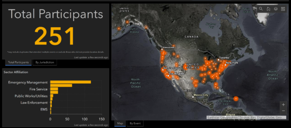
NAPSG Foundation is compiling publicly accessible COVID-19 geospatial and situational awareness resources from a variety of sources for the purpose of providing a clearinghouse of resources that may be helpful to the public safety and GIS/technology community in responding to COVID-19. This page will be updated as new resources become available.

Power of Partnerships in Data & Technology for COVID-19 Response

Pandemic GIS Task Force Launched

NAPSG Foundation, the National States Geographic Information Council (NSGIC), and the Urban and Regional Information Systems Association (URSIA) have joined forces to provide unified leadership in advancing the use of location-based data, technology, and information sharing for pandemic preparedness and response. The three national organizations have launched a Pandemic GIS Task Force that will be leading the development of a national strategy and plan of action to enable intelligence-led pandemic preparedness and response through the use of GIS data, technology, and information sharing.

National Inventory of Health/Medical Capability Data Feeds

We are requesting the geospatial community to participate in a nationwide effort to build an inventory of existing data feeds for health/medical capability reporting in support of COVID-19 – and for increasing public health data preparedness in the future.

Click here for additional information on this effort.

FEMA Resources for Emergency Response & Management Community

FEMA Launches COVID-19 Geospatial Resource Center

Federal, State, Local, Tribal, and NGO partners responding to COVID-19 can now share authoritative data, maps and apps with the emergency management community through the new FEMA COVID-19 Geospatial Resource Center. This site facilitates geospatial authoritative data sharing, collaboration, and situational awareness. You can contribute to this nationwide effort to collect data, apps, and maps. Your contributions will ensure decision-makers at every level of government have the information they need to allocate resources and plan for their communities.

Free Access to GIS Software

State, local, tribal, and territorial government entities can now obtain free access to Esri software for up to 6 months to help respond to COVID-19. To take advantage of this opportunity, choose “Request Assistance” in the red banner, and then select “COVID-19 Response Package.”

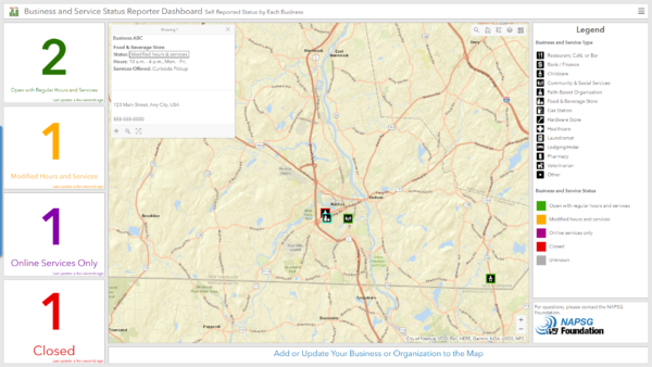
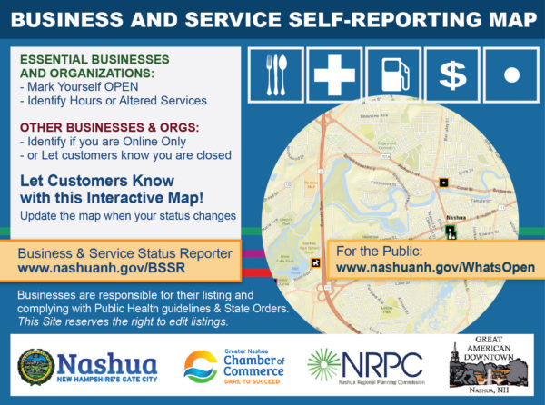
COVID-19 State-Level Geospatial Resources

Use the interactive map below to access publicly available state-level GIS viewers and dashboards made available to support COVID-19 response. Additional state-level resources will be added to this map as they become available.

COVID-19 Resources for Law Enforcement, Fire Service, and EMS

Police: The National Police Foundation is compiling the most relevant and authoritative guidance for police and law enforcement agencies on COVID-19. They have also launched the Law Enforcement COVID-19 Personnel Impact & PPE Survey and Dashboard, which are intended for participation by police and law enforcement agencies nationwide.


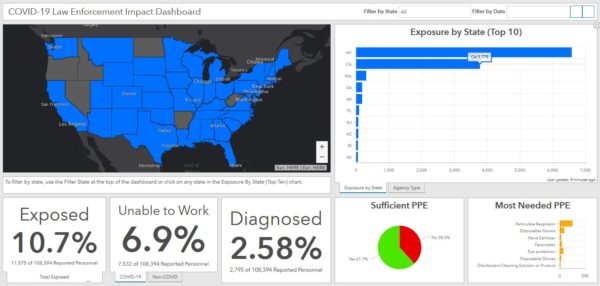
Sheriffs: The National Sheriff’s Association has launched the Sheriff’s COVID-19 Personnel Impact & PPE Questionnaire and Dashboard to support all sheriffs nationwide. View the Sheriff Impact & PPE Dashboard.

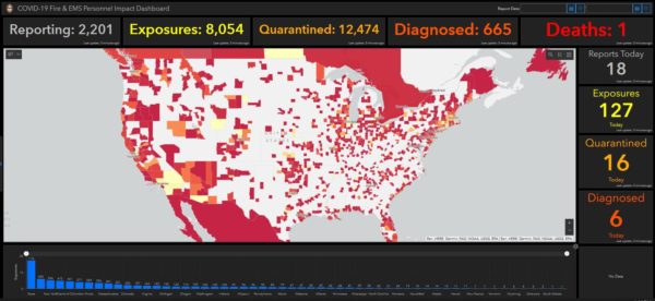
Fire & EMS: The International Association of Fire Chiefs (IAFC) has compiled critical resources and guidance to aid fire and EMS agencies in preparing for and responding to occurrences of COVID-19. Additionally, the IAFC is collecting regular reports on COVID-19 impact from fire and EMS departments and providing real-time analysis on impact.


Expanded Access to HIFLD Licensed Data Now Available

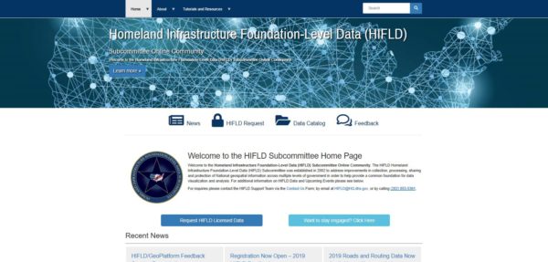
As Emergency Management and Homeland Security Mission Partners respond to the COVID-19 outbreak, all applicable licensed datasets have been released to local, tribal, and territorial users with COVID-19 operational needs. This expanded access covers these additional data products:

  • Licensed Parcel Data
  • 2020 Roads and Routing Dataset
  • Dun & Bradstreet Business Points Data

Link to more information and access: https://www.napsgfoundation.org/hifld_covid19/

Access the Esri COVID-19 GIS Hub

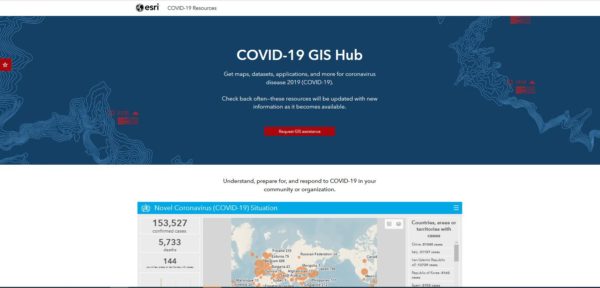
On the COVID-19 GIS Hub, you will find valuable and ready-to-use demographics and other data from the best available sources, the user community, and business partners. You will also find practical apps that immediately aid better understanding and decision-making. This includes a collection of datasets, applications, and other useful content for your planning and response. These materials will be updated with new content as it becomes available.

Link to COVID-19 GIS Hub: https://coronavirus-resources.esri.com/

Esri Solutions for Public Health COVID-19 Response

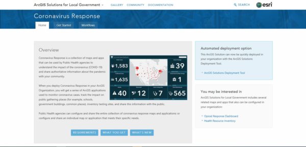
Public Health agencies can configure and share the entire collection of Coronavirus response maps and applications, or configure and share an individual map or application that meets their specific needs using templates provided by Esri.

Guidance from Esri on Understanding the Potential COVID-19 Impact on Your Organization or Community

  1. Map the cases—Map confirmed and active cases, deaths, and recoveries to identify where COVID-19 infections exist and have occurred.
  2. Map the spread—Time-enabled maps can reveal how infections spread over time and where you may want to target interventions.
  3. Map vulnerable populations—COVID-19 disproportionally impacts certain demographics such as the elderly and those with underlying health conditions. Mapping social vulnerability, age, and other factors help you monitor at-risk groups and regions you serve.
  4. Map your capability to respond—Map facilities, employees or citizens, medical resources, equipment, goods, and services to understand and respond to current and potential impacts of COVID-19.
  5. Communicate with maps—Use interactive web maps, dashboard apps, and story maps to help rapidly communicate your situation.

Request Assistance from Esri’s Disaster Response Program

If your organization’s GIS capacity is exceeded and you need emergency support, there are several ways Esri may be able to help.

Please reach out to Esri at https://go.esri.com/e/82202/disaster/mz9mmw/732591364?h=FN11XNQ3VMisKuuXOWHet80KbndG0xE5j7iKRvHzlTw and click “Request Assistance.” And, if you have data or solutions that would be useful to others, you can share them with Esri for potential inclusion in Esri’s COVID-19 GIS Hub and make them accessible to the global community.

Geospatial Tools for SAR & First Responders

On January 30th, 2020, the FEMA Response Geospatial Office (RGO) and NAPSG Foundation hosted an Emergency Management (EM) Geo Forum to discuss geospatial resources and best practices that aid in search and rescue (SAR) operations.

Seminar Objectives

In this EM Geo Forum, participants:

  • Learned the purpose of SAR data collection and the ways in which this data can be used.
  • Learned field data collection methods and ways to integrate them into an organization.
  • Learned how to develop an organizational game plan to transform data and technology into actionable information that changes the outcome for survivors.
  • Gained insight into FEMA’s timeline and geospatial strategy for SAR.
Speakers

This EM Geo Forum featured speakers from the emergency management community who have first-hand knowledge and experience in SAR operations.

  • Paul Doherty, PhD, NAPSG Foundation
  • Jared Doke, NAPSG Foundation
  • Adam Barker, PhD, FEMA Response Geospatial Office
  • Lance Gilmore, FEMA Urban Search and Rescue
Seminar Resources
SAR Summary Dashboard
SAR Summary Dashboard from NAPSG’s SAR Geospatial Resources
Background Information

The Emergency Management (EM) Geo Forum is part of a virtual seminar series featuring best practices and resources to advance emergency management through geospatial capabilities. These seminars promote the integration of innovative technology and solutions in day-to-day operations.

Materials Available – 2019 Innovation Summit for Preparedness and Resilience

Day 1Day 2Day 3
About InSPIRE
2019 Disaster Innovation Talks ↗


Back to Top

Day 1
Welcome and Opening Ceremonies
Disaster Innovation Talks
Concurrent Sessions
Emerging Technologies Showcase


Back to Top

Day 2
Welcome and Opening Ceremonies
Disaster Innovation Talks
Concurrent Sessions


Back to Top

Day 3
Concurrent Workshops and Special Meetings


Back to Top

About InSPIRE 2019

NAPSG hosted the Innovation Summit for Preparedness & Resilience (InSPIRE) on November 12-14 at Texas A&M University at Galveston. The summit brought together more than 200 public safety and homeland security leaders, first responders, and GIS professionals representing 38 states and 137 agencies. The summit was co-hosted by Texas A&M University at Galveston and conducted in partnership with the US Department of Homeland Security Science & Technology Directorate, International Association of Fire Chiefs, International Association of Emergency Managers, National Association for Search & Rescue, the National States Geographic Information Council, and other partner organizations.

InSPIRE is the nation’s only summit dedicated to fostering innovation in policy and technology for preparedness and resilience. Programming is designed for federal, tribal, territorial, state, and local governments and is crafted to foster innovation to build a culture of preparedness, strengthen communities, and increase resilience nationwide.

2019 Disaster Innovation Talks

The 2019 NAPSG Disaster Innovation Talks were delivered as part of the 2019 Innovation Summit for Preparedness and Resilience (InSPIRE) on November 12-13 at the Texas A&M University at Galveston. Provided below are the video recordings.

For all other InSPIRE materials, visit: 2019 InSPIRE Materials

Jump to individual videos using the navigation cards below.


Back to Top

Applying Science & Technology to Drive State Flood Mitigation and Resilience Policy

Dr. Sam Brody, Director, Center for Texas Beaches & Shores, Texas A&M University Galveston


Back to Top

Enhancing Life Saving Missions with Innovative Technology & Policy

Jeff Maunder, Manager, New Zealand Disaster Assistance Response Team, New Zealand Urban Search & Rescue National Management Team


Back to Top

Shifting the Paradigm: The Role of Mitigation Following Hurricane Harvey

Josh Davies, Division Chief, Texas Division of Emergency Management


Back to Top

Turning Science & Technology into Disaster Decision Making

Jacqueline Meszaros, Ph.D., Science and Technology Advisor; Natural Hazards, Disasters, and Resilience; National Science Foundation


Back to Top

Achieving Interoperability for Crisis Management in the Field and at the State EOC

Steven Batson, Chief of Staff, South Carolina Division of Emergency Mgmt


Back to Top

Learning to See What Others Can’t

Ryan Lanclos, Director, Public Safety Industries, Esri


Back to Top

Technology Enabling the Community Lifelines for Local and State Incident Operations

Michael Dossett, Director, Kentucky Emergency Management • Doug Eades, GIS Lead, Kentucky Emergency Management


Back to Top

Integrating Intelligence and Technology to Drive Operational Planning

David Kang, Director, Response Planning and Exercise Division, Federal Emergency Management Agency

Situational Awareness for the Living Room

PrepTech Talks logo

Webinar Recording
Slide Deck
Tech Innovation Website (prototype)

On December 10th, 2019, NAPSG Foundation held its fifth PrepTech Talk titled “Situational Awareness for the Living Room: Cracking the Code on Public Information Maps.” This virtual seminar provided participants the opportunity to hear from Sonoma County, CA, on the development of their Public Information Map Game Plan and to learn best practices identified in public information mapping as part of NAPSG’s Technology Innovation for Flood Preparedness & Operations initiative supported by the DHS Science and Technology Directorate. The feedback from this event indicates that the Community would like more guidance on public information maps, so look out for future PrepTech Talks and other opportunities on this topic!

SEMINAR OBJECTIVES
  • Develop a better understanding of common challenges associated with NOT using maps for public information sharing and the benefits of using public information maps.
  • Develop a checklist of best practices for public information maps.
    • Technical
    • Operational
  • Provide a draft worksheet for maintaining and sharing public information maps as part of a geospatial game plan.
SEMINAR RESOURCES
Learn the Latest in Preparedness Technology & Tools

PrepTech Talks logo

Webinar Recording
Slide Deck
FEMA’s Preparedness Toolkit

On September 19, 2019, NAPSG Foundation held its fourth Preparedness Technology Talk, “Learn the Latest in Preparedness Technology & Tools.” This PrepTech Talk provided participants the opportunity to learn from a panel of experts from local, state, and Federal agencies on how they are using the latest available technology-enabled tools and resources to support high impact preparedness efforts.

SEMINAR OBJECTIVES
  • Discuss the basics of PrepToolkit, how to access it, and the types of resources available.
  • Learn how to leverage location-enabled tools to develop plans and realistic exercise scenarios with or without technical and geospatial staff.
  • Provide tools & guidance for Geospatial Staff who support the emergency management community.
  • Learn from industry leaders on the implementation of PrepToolkit tools and resources in their communities.
SEMINAR RESOURCES
ADDITIONAL RESOURCES
  • Hazard Explorer Suite  – Suite of tools, templates, and guidance for integrating geospatial data and analysis from preparedness to recovery.
  • Hazard Explorer Tool – Tool to help Exercise Planners identify and evaluate potential exercise scenario locations, hazard exposure, and other risk-related factors to support exercise planning.
  • FEMA’s Preparedness Toolkit – Resources to assist the community in implementing National Preparedness Activities, including Hazard Explorer.
Get Smart on Information-Sharing Standards for Crisis Management

PrepTech Talks logo

Webinar Recording
Slide Deck
Implementation Guidance

On September 5th, 2019, NAPSG Foundation held the Preparedness Technology Talk “Get Smart on Information-Sharing Standards for Crisis Management.” This PrepTech Talk provided participants the opportunity to learn how to guide their technology vendors and partners in implementing existing information-sharing standards to support interoperability among their agency and regional mutual aid and crisis management systems.

SEMINAR OBJECTIVES
  • Learn the basics of existing information-sharing standards and which ones apply to mutual aid, resource management, and crisis management technology systems.
  • Learn why it is critical to ensure your systems interoperable and capable of seamless information exchange among agencies and response partners.
  • Develop skills on how to guide your technology vendors and partners in implementing the most appropriate information sharing standards.
  • Gain access to the latest Implementation Guidance so that you can begin developing your agency and regional game plan to improve interoperability!
SEMINAR RESOURCES
BACKGROUND INFORMATION

NAPSG Foundation has been working with the community to understand what existing standards are out there that support information sharing among mutual aid, resource management, and crisis management systems.

Following extensive research and analysis, we’ve developed a draft Implementation Guidance to support your efforts to increase mission-critical information exchange and seamless interoperability. 

Aligning & Standardizing Response Map Products to Community Lifelines

PrepTech Talks logo

Webinar Recording
Slide Deck
Community Lifeline Toolkit

On July 31st, 2019, NAPSG Foundation held its second Preparedness Technology Talk, “Aligning & Standardizing Response Map Products to Community Lifelines.” This PrepTech Talk provided participants the opportunity to learn how to align GIS-based decision support tools and dashboards to the Community Lifelines, and how to gain access to resources and data that support standardization and ease implementation.


SEMINAR OBJECTIVES
  • Learn about the Community Lifeline construct and how to integrate it with your agency’s GIS-based decision support tools and dashboards.
  • Get a live demonstration of emerging best practices in aligning operational dashboards to the Community Lifelines.
  • Develop skills in how to develop a standardized response map products to the latest National Response Framework.
  • Learn about Open Data through HIFLD that supports the Community Lifelines and how it supports essential elements of information (EEIs) for standardized map products, dashboards, and situational awareness tools.
  • Gain access to the latest in resources and tools for developing and implementing standardized map products, dashboards, and other situational awareness capabilities aligned with the Community Lifelines. 
SEMINAR RESOURCES

Link to Recording
Slide deck with Additional Content

ADDITIONAL RESOURCES
BACKGROUND INFORMATION

FEMA recently introduced and is rolling out the Community Lifelines construct as part of an update to the National Response Framework. Each of the lifelines provides indispensable services that enable the continuous operation of critical business and government functions, and they are critical to human health, safety, and economic security. Learn more:

Open data is available through the Homeland Infrastructure Foundation Level Data (HIFLD) program that fulfills EEIs aligned with the Community Lifelines. During this seminar, you will learn how to integrate data from HIFLD into your response map products and implement standardized symbology.

Implementation Guidance: Information Sharing Standards

July 2, 2019

The National Alliance for Public Safety GIS (NAPSG) Foundation released the first version of the Implementation Guidance: Information Sharing Standards for Crisis Management Mutual Aid Technology.

The purpose of this Implementation Guidance is to serve as a simple guide on choosing the appropriate information sharing standard for a given need, as well as, identifying key considerations for communicating information between systems. 

The Implementation Guidance was designed to support two audiences:

  1. Public Safety Leaders – Designed to help them determine best options for their needs and properly communicate those requirements
  2. Technologists/Vendors – Intended to help guide technical implementation and provide technical guidance on information sharing standards

This Guidance is available to access and download at: https://www.napsgfoundation.org/all-resources/standard-operating-guide-templates/


Geo-enable Search & Rescue in Disasters

PrepTech Talks logo

Webinar Recording
Slide Deck
SAR & First Responder Toolkit

On June 26th, 2019, NAPSG Foundation launched the new Virtual Seminar Series called Preparedness Technology Talks – PrepTech Talks. The first seminar in the PrepTech Talk series, “Geo-Enable Search & Rescue in Disasters,” provided participants the opportunity to train and gain access to a standardized suite of tools and common framework for geo-enabling Search and Rescue (SAR) missions for disaster response.

Seminar Objectives
  • Learn who to contact in order to gain access to the existing field apps hosted by FEMA Urban Search & Rescue (USAR) and the International Association of Fire Chiefs (IAFC).
  • Understand how to use basic field data collection tools (Survey123 configured with the SAR and First Responder Survey template).
  • Understand how to quickly analyze and report against live field data for situational awareness.
  • Begin to develop your own geospatial game-plan and access additional resources.

If you would like to participate in a brief hands-on exercise, please also install the Survey123 Field App on your mobile device.

  1. Go to this website  https://www.esri.com/en-us/arcgis/products/survey123/resources, or search for “Survey123 for ArcGIS”.
  2. Install the application; no cost to download.
  3. If you have been assigned an ArcGIS Online Username, you can use that but it is not necessary for the exercise.
  4. More instructions will be provided during the virtual training.

This SAR & First Responder Geospatial Toolkit is produced & maintained by NAPSG Foundation based on work performed by the USAR Field Data Working Group. This is a group of search and rescue professionals who coordinate with the purpose of preparing for large-scale incidents and developing a common data schema for field data collection.

Seminar Resources
A screenshot from the 2018 Hurricane Season showing both FEMA and State Search and Rescue waypoints on one map.

A screenshot from the 2018 Hurricane Season showing both FEMA and State Search and Rescue waypoints on one map.

New Technology Preparedness Toolkits Available

NAPSG Foundation is pleased to share two new technology-focused toolkits that were recently launched and are available to the community today, as a part of NAPSG’s Safe & Resilient Toolkit. Each of the toolkits provides public safety leaders, emergency managers, and first responders with consistent guidance and resources for building and enabling the use of location-based technology during incident operations.

While both of the toolkits are designed for use in response to an incident, leaders and first responders should review and begin applying the guidance in building capability during the clear skies, preparedness phase.

Below is a short synopsis of the two new toolkits that are accessible in the Resource Library!

First Responder and SAR Geospatial Toolkit – Use this toolkit to adopt a common geospatial framework and train for disaster response missions.

CrowdsourceEM Toolkit – Use this toolkit to build a crodsourcing capability in your community.

NAPSG Featured Content

2018 Disaster Innovation Talks

The inaugural series of NAPSG Disaster Innovation Talks were delivered as part of the 2018 National Geospatial Preparedness Summit on December 3-4 at the University of Colorado, Boulder. Provided below are the video recordings. For all other NGPS Materials, visit: https://www.napsgfoundation.org/resources/materials-2018-ngps/.

Smart to Wise: One City’s Journey in Overcoming Preparedness Challenges with Technology

Mike Chard, Director, City and County of Boulder Office of Emergency Management

Connecting the Human Dimension of Hazards and Disasters

Dr. Lori Peek, Director, Natural Hazards Center – University of Colorado

Uniting Response and Communications with FirstNet

Jeff Bratcher, Chief Technology Officer, FirstNet

Reducing Complexity and Improving Decision Making with Response Lifelines

Josh Dozor, Deputy Assistant Administrator for Response, Federal Emergency Management Agency

A Ready and Resilient Nation through Innovation

Daniel Alexander, Director, National Integration Center, Federal Emergency Management Agency

Cracking the Code on indoor Incident Operations

Jeb Benson, Public Safety Communications Research, National Institute of Standards and Technology

Data for Good: Social Media Aiding in Disaster Response and Recovery

Laura McGorman, Policy Lead for Disaster Maps, Facebook


Materials Available – 2018 National Geospatial Preparedness Summit

On December 3-5, 2018, the National Alliance for Public Safety GIS (NAPSG) Foundation brought together over 240 of the nation’s public safety leaders and GIS professionals for the 4th annual National Geospatial Preparedness Summit (NGPS). The 2018 NGPS was hosted at the University of Colorado in Boulder in collaboration with the Natural Hazards Center and the US Department of Homeland Security’s Science and Technology Directorate.

NGPS is the nation’s only preparedness Summit dedicated to advancing the use of innovative technology for emergency management and first responders. NGPS weaves together a unique combination of cutting-edge education and training programs involving hands-on training, policy workshops, and field-oriented exercises. This year’s programming featured a series of Disaster Innovation Talks by our nation’s most prolific leaders in technology innovation and emergency management, a national roundtable on emerging technology, a live field simulation, and hands-on technical GIS training. This year’s summit culminated in a functional exercise focused on implementing and sharing core operational information prior to, during, and after a major winter storm. Participants shared experiences from recent disasters, deepened skills and knowledge, built relationships, and developed real solutions to the most vexing challenges in implementing innovative technology for disaster preparedness and response.

Provided below is a copy of the 2018 NGPS Agenda linked with the materials from nearly all sessions and Disaster Innovation Talks. Please use this material as a reference tool in your efforts, and be sure to provide proper attribution to the individual content author when referencing the materials in your writing, presentations, or other related materials.


Day 1: December 3

Day 2: December 4

Day 3: December 5

Materials Available – 10th Annual Search & Rescue GIS Workshop (SARGIS10)

NAPSG Foundation’s Search & Rescue GIS Working Group gathered with more than 60 Search & Rescue (SAR) leaders and GIS responders at West Valley College in Saratoga, California, on October 23-25th, 2018, for the highly anticipated 10th Annual Search & Rescue GIS Workshop. This year’s theme was “The Next Generation of Geospatial for SAR”.

The purpose of the SAR GIS Workshop was to build capacity and advance the use of location and analytics-based decision support tools across the SAR community for missing persons and disaster SAR. The diversity of perspectives and experiences generated a rich dialogue around challenges and potential solutions.

The workshop started with an opening keynote presentation by Kip Harkness, Deputy City Manager for the City of San Jose. Kip engaged the audience with the following topics, based on his experience during recent flood events in San Jose:

  • Be Compassion, In Action – Get outside the command post or operations center to see the people you are supposed to be helping.
  • Be Open, Candid, and Direct – Honesty is always the best policy, and in disasters it is a necessity for a swift and capable response. “Face the brutal facts”.
  • One Team, One Fight – No one should get left behind in disaster, whether they are your most vulnerable citizens or emergency managers themselves.

Kip Harkness, City of San Jose Deputy City Manager, providing the keynote presentation.

Kip’s presentation was heartfelt and a good reminder that while advancing technology helps solves problems, humans are at the center of our work. Two emergency managers from Kip’s team joined us for the rest of the workshop and will be taking some lessons learned back with them to the Office of Emergency Management in San Jose.

This keynote presentation was followed by presentations from across the SARGIS Community, a panel discussion on drones and cell phone analysis, and lightning talks by local practitioners on emerging best practices. The 2nd day of SARGIS10 included a full day of training for First Responders and GIS Specialists.

Check out the SARGIS10 Agenda

Below are some no-cost resources made available following the event:

  • Basic Training Story Map
    • What is SARGIS?
    • Basics of SAR and GIS
    • Using GPS & Paper Maps
    • Example SAR Maps & Apps
    • Using MapSAR Online
    • How to Prepare Incident Data
    • How to Prepare a Situational Awareness Viewer
    • Prepare a Field Data Collection App
    • Using MapSAR Pro
  • Disaster Situational Awareness & Reconnaissance (DSAR) Efforts: Hurricane Florence & Michael [PDF]
  • Cellphone Forensic Analysis for SAR [PDF]
  • Initial Response and Reflex Tasking [PDF]
  • Lost Person Behavior Models and Terrain Analysis [PDF]
  • Integrated Geospatial Tools for Wilderness Search and Rescue – IGT4SAR [PDF]
  • Operational Guide to Using Cellphones for SAR [PDF]
  • Postcards from the Flood – Stories of Technology & Disaster [PDF]
  • Next Generation ArcGIS Apps for SAR [PDF]
  • Introduction to Wildland SAR for GISS [PDF]
  • NWCG GISS Training Website Awareness [PDF]
  • Native American Missing Persons [PDF]
  • UAS (Unmanned Aerial Vehicle) Mission Planning Apps [PDF]

The SARGIS Training Website with materials used during SARGIS10.

Field Exercise
On the third day, we simulated field data collection after a major earthquake in San Jose. This was to test the interoperability between Urban and Wilderness Search and Rescue Teams. The Field Exercise was a great success with teams out in the field using Survey123 and Collector for ArcGIS and testing an early version of Tracker for ArcGIS in real-time. GIS Teams inside had a “hackathon” to produce Story Maps, Situational Awareness Viewers, and Operations Dashboards. Overall, it was a great experience and some new workflows were tested and improved.

SARGIS10 FieldEx Dashboard showing waypoints collected using Survey123 and search coverage with Tracker for ArcGIS. To access the SAR Field Data Collection template, see this Deployment Kit.

Recognition
A very special thank you to the event planning team who volunteered many hours leading up to the event: Vanessa Glynn-Linaris (PSC), Hilary Melton (LSC), Jared Doke (OSC), Caroline Rose, George Durkee and Don Ferguson. Finally, thank you to our site host Chris Cruz (and students) at West Valley College, and Chris Ferner & Doug Morgenthaler from the Esri Disaster Response Program for on-site support.

Feeling left out? Explore the #SARGIS10 conversations and photos on Twitter!

SARGIS10 Photo from a MavicPro2 – Credit: Chad Sperry

NAPSG Situational Awareness Viewer

Monitor current events and severe weather forecasts using this dynamic Situational Awareness Viewer provided by NAPSG Foundation to support incident and disaster readiness across several natural hazards nationwide. For full access to the NAPSG SA Viewer visit: https://arcg.is/0imPXC.


Core Information Guideline Available

June 28, 2018

The National Alliance for Public Safety GIS (NAPSG) Foundation released the first version of the First Responder Core Information Guideline.

The purpose of this Guideline is to provide first responders and decision makers with a standardized framework for Core Operational Information in support of flood and other hazards.

This Guideline aligns the key decision points with essential elements of information for supporting effective decision making in floods and other types of events. By design, this guideline supports flexible, scalable, and practical implementation.

It also includes GIS Technical Implementation Guidance for GIS Staff to use in working with first responders, emergency managers, and other public safety decision makers in developing and configuring decision support tools that provide them with the core information required for preparedness, response, and recovery.

The First Responder Core Information Guideline and Technical Implementation Guidance is available in an interactive format at: https://www.napsgfoundation.org/all-resources/standard-operating-guide-templates/

This Guideline was produced with support from the US Department of Homeland Security (DHS) Science and Technology Directorate (S&T), agreement number HSHQDC-16-C-B0016.

Resource Management Dashboard Guidance

January 1, 2018

The National Alliance for Public Safety GIS (NAPSG) Foundation released the first version of the Resource Management Dashboard Guidance.

The purpose of this Guidance is to provide a consistent framework and functional specifications for developing and using location-enabled dashboard technology to support resource management.

This Guidance on Resource Management (RM) Dashboards was designed to support all public safety disciplines and all types & scales of incidents. Example RM Dashboards are provided for several disciplines in order to illustrate how the consistent framework can be applied to different missions.

It also includes a Technical Tutorial for GIS Staff to use in getting started in developing and configuring an RM Dashboard using Esri-based GIS software.

The Guidance is available in both an interactive format and print version at https://www.napsgfoundation.org/all-resources/standard-operating-guide-templates/.

Image of the landing page for the interactive version of the Guidance on Resource Management Dashboards

Materials Available – 9th Annual Search & Rescue GIS Workshop (SARGIS9)

On November 6-8, 2017, NAPSG Foundation’s Search & Rescue GIS Working Group gathered with more than 50 Search & Rescue (SAR) leaders and GIS responders at the Esri Office in Broomfield, Colorado, for the highly anticipated 9th Annual Search & Rescue GIS Workshop. The purpose of the SAR GIS Workshop was to build capacity and advance the use of location and analytics-based decision support tools across the SAR community for missing persons and disaster SAR. The diversity of perspectives and experiences generated a rich dialogue around challenges and potential solutions.

The workshop included keynotes from national SAR leaders, lightning talks by local practitioners on emerging best practices, and it culminated with a work session to bring technology and operations together. Additionally, the workshop provided hands-on basic and advanced training on building GIS products and solutions to support incident management and SAR operations.

Provided below is copy of the SAR GIS Workshop Agenda linked with the materials from nearly all sessions and keynote addresses.

** Please feel free to use this material as a reference and tool in your efforts, and be sure to provide proper attribution to the individual content author when referencing the materials below in your writing, presentations, and other related material.**

To learn more about the NAPSG Foundation SAR GIS Working Group, visit: http://arcg.is/1LuO9L.

SARGIS9 Workshop Agenda

Day 1 – Materials

What is SARGIS? Who We Are & What We Do [PDF] [YouTube]

  • Paul Doherty & Jared Doke | NAPSG Foundation

The Role of Geospatial in Urban Search & Rescue [PDF]

  • Scott Olsen Boone County Fire Protection District

The Role of Geospatial in National Park Service Emergency Services [PDF]

  • Andrew Hower National Park Service

MyUSNG + Explorer for ArcGIS [PDF]

  • Doug Morgenthaler | Esri

The Role of Geospatial in the Mountain Rescue Association [PDF]

  • Bryan Enberg | Mountain Rescue Association

Case Study: Snow Leopard SAR [PDF] [YouTube]

  • Curtis DeVault Gallatin County Search & Rescue

Lessons Learned from Hurricanes Harvey, Irma, and Maria [PDF] [YouTube]

  • Carla Boyce NAPSG Foundation

Case Study: Use of Unmanned Aircraft Systems (UAS) in SAR [PDF] [YouTube]

  • Brandon Torres Grand Canyon National Park

Technology Speed Geeking: Lightning Talks [YouTube]

  • Probability of Area in SAR [PDF]
  • FEMA GIS: Parcel Data for Response [PDF]
  • Maps + Apps + Rangers [PDF]
  • Taking WebGIS Maps with You [PDF]
  • I’ve got Drones…now what? Emerging patterns of UAS in SAR [PDF]

Day 2 & 3 – Materials

See SAR Training website.


Materials Available: Hurricane Irma Search & Rescue GIS Hot Wash and Workshop

On September 2017, NAPSG Foundation and the International Association of Fire Chiefs (IAFC) coordinated with the Florida Fire Chiefs Association (FFCA), Florida State Fire Marshal’s Office, and the Florida Division of Emergency Management to provide location-enabled decision support tools and field information collection tools to local and state SAR teams positioning and deploying in support of Hurricane Irma. NAPSG Foundation and the IAFC rapidly developed and deployed a prototype suite of decision support tools and field data collection applications for an estimated 300 of local and state fire and SAR responders representing roughly 56 teams or task forces preparing for and responding to Hurricane Irma.

A Hot Wash and Workshop was conducted on November 3, 2017, at the Orlando Fire Rescue headquarters in Winter Park, Florida – to foster dialogue, examine lessons observed, and capture feedback by the fire service and SAR personnel who used advanced technology for situational awareness and field information collection primarily during Hurricane Irma. The Hot Wash and Workshop was co-hosted by the IAFC, FFCA, the Florida State Fire Marshal, and the National Alliance for Public Safety GIS Foundation. The stakeholder feedback captured during just-in-time trainings, informal discussions with first responders, and through the hot wash discussions serve as valuable forums to define specific requirements needed to inform the solutions and tools for improved decision making by fire and SAR operators and leaders prior to future disasters.

Provided below is the copy of the Agenda and some of the materials used in the Hurricane Irma SAR GIS Hot Wash and Workshop. The After Action Report from this effort will be posted shortly.

**Please feel free to use this material as a reference and tool in your efforts, and be sure to provide proper attribution to the individual content author when referencing the materials provided below in your writing, presentations, and other related material.**

Agenda for the Irma SAR GIS Hot Wash

Key Resources:

To learn more about the NAPSG Foundation SAR GIS Working Group, visit: http://arcg.is/1LuO9L.

Virtual Training: Enhancing Mission Critical Decision Making

On Thursday, October 26, 2017, the National Alliance for Public Safety GIS (NAPSG) Foundation hosted a virtual training focused on “Enhancing Mission Critical Decision Making: Understanding Core Information Requirements”. This virtual training provided participants with the opportunity to:

  • Gain awareness level knowledge on the process and national baseline for defining core information requirements to support mission critical decision making.
  • Learn about a common framework for developing your agency’s core information requirements, starting with the decisions you make in routine incidents and larger-scale disasters.
  • Gain insight on national core information requirements for mutual aid consistent for all hazards and threats.
  • Learn about the national flood-specific core information requirements.
  • Develop strategies for communicating your information needs to GIS staff and technologists, so they can provide you with the most effective decision support tools and solutions.

Provided below are the links to the recording and the materials used in this virtual training:

Available Now! Hurricane Maria Crowdsourcing Photo App

September 19, 2017 – The National Alliance for Public Safety GIS (NAPSG) Foundation launched a crowdsourcing application to help collect photos and images taken by citizens on the ground during and after Hurricane Maria.

  • If you are on the ground in the impact area (and are safe!), you can contribute your photos to the app very easily using your mobile device.
  • You can also use the app if you are trying to assess the type and extent of damage in the impacted areas to:
    • Prepare for mutual aid response
    • Support situational assessment
    • Aid operational readiness for deployment to the field
    • Other response and recovery functions

Check it out, share it around, and if you are there – contribute!


Basic Hurricane Maria Incident Map Available

September 27, 2017

The National Alliance for Public Safety GIS (NAPSG) Foundation developed a basic overview of the most relevant available geospatial information for areas impacted by Hurricane Maria, specifically focused on Puerto Rico.

This basic story map provides information on key themes relevant to hurricane response and recovery efforts, including but not limited to:

  • Shelter with status information
  • Demographics
  • Communication infrastructure locations
  • Health facility locations
  • Crowdsourced information on other hazards and problems such as: reported power outages, bridge collapses, etc.
  • Transportation information including live traffic feeds

Check it out and share it around for those in need of basic Hurricane Maria information in Puerto Rico.

Available Now! Hurricane Irma Resources & Crowdsourced Photo App

September 6, 2017

NAPSG Foundation has launched a Hurricane Irma GIS Resources group and webpage to provide critical resources for first responders and decision makers supporting Hurricane Irma response and recovery.

The Hurricane Irma GIS Resources group and webpage includes the following:

  • USNG Map Book Downloader
  • USNG 1:25K Map Books for Puerto Rico and the US Virgin Islands – Developed in partnership with Delta State University
  • Hurricane Irma Data, Web Maps, and AppsBest available for public access
  • USNG Resources for Citizen Safety During Irma

NAPSG Foundation is working closely with its partners to address the highest priority requests for GIS-based decision support tools by first responders deployed(ing) in the field for Hurricane Irma.

Additionally, NAPSG Foundation launched a crowdsourcing application to help collect photos taken from the field during and after Hurricane Irma.

  • If you are on the ground in the impacted area, you can contribute your images to the app very easily using your mobile device.
  • You can also use the app if you are trying to assess the type and extent of damage in the impacted areas to:
    • Prepare for mutual aid requests
    • Support situational assessment
    • Aid operational readiness for deployment to the field
    • Other response and recovery functions

Check it out, share it around, and if you are there – contribute!

Open Data for Hurricane Harvey

Hurricane Harvey Best Available Data

August 29, 2017 – At the request of FEMA, the Department of Homeland Security (DHS) Geospatial Management Office and the Department of Interior (DOI) stood-up a dedicated Open Data Site (HIFLD for Harvey) to aggregate the most relevant and best available data in a single place – to support Hurricane Harvey response and recovery across all levels of government and whole community partners. HIFLD for Harvey is publicly available at the link below:

HIFLD for Harvey is a part of the Federal Geospatial Platform infrastructure. NAPSG is honored to be a part of the HIFLD team with DHS, DOI, and ArdentMC in this critical effort.

Data Available Now

Over 60 data sets are accessible now in HIFLD for Harvey providing the best available data for Harvey-specific information requirements. More data is being added around the clock. This site is being curated to ensure it’s the most relevant and best available data for Harvey operations.

USNG Map Books for Affected Counties

HIFLD for Harvey contains 1:25K USNG Map Books for the affected counties. Map books for each county are being added to the site as produced, with 15 county map books available now. This is a critical resource for first responders and others supporting response and recovery operations. USNG Map Books are being produced in partnership with Delta State University.

How You Can Contribute to HIFLD for Harvey

  • Spread the Word! – Use #HIFLD4Harvey in social media posts. Share the website out with your friends and colleagues in anticipating GIS needs, mutual aid requests, and any related response/recovery efforts.
  • Got Data for Harvey? – If you have data that is directly relevant to Harvey that you consider best available, send an email with the link to the data to HIFLD@hq.dhs.gov.
  • Unmet Mission Critical Data Needs? – If you have identified a mission critical information requirement that is not currently supported by data available in HIFLD for Harvey, please let us know what the need is by sending an email to HIFLD@hq.dhs.gov.

Other relevant GIS resources for Harvey are available here: https://www.napsgfoundation.org/hurricane-harvey-resources/

Crowdsourcing App for Hurricane Harvey Available Now

August 26, 2017 – The National Alliance for Public Safety GIS (NAPSG) Foundation launched a crowdsourcing application to help collect images taken from the field during and after Hurricane Harvey.

  • If you are on the ground in the impact area, you can contribute your images to the app very easily using your mobile device.
  • You can also use the app if you are trying to assess the type and extent of damage in the impacted areas to:
    • Prepare for mutual aid requests
    • Support situational assessment
    • Aid operational readiness for deployment to the field
    • Other response and recovery functions

Check it out, share it around, and if you are there – contribute!

Virtual Training: HIFLD Open is on the Move

On Tuesday, October 10th, the National Alliance for Public Safety GIS (NAPSG) Foundation hosted a virtual training with the US Department of Homeland Security (DHS) Geospatial Management Office (GMO) on HIFLD Open. The purpose of this training is to:

  • Gain awareness level knowledge on the latest developments of the Homeland Infrastructure Level Data (HIFLD) and key lessons learned from its use in recent events.

This virtual training offers the opportunity to:

  • Learn about the latest updates to HIFLD Data and the HIFLD Open migration to the federal GeoPlatform
  • Gain insights on how the HIFLD Open migration impacts you and any web applications that you have using HIFLD data
  • Learn about lessons learned and emerging best practices in applying HIFLD data in support of larger-scale disasters
  • See live demonstrations of decision support tools used in recent events that use HIFLD data in support of larger-scale disasters

Provided below are the links to the recording and the materials used in the virtual training:

Virtual Training: Implementing Standard Incident Level Symbology

While national and international standards fulfill some symbol needs, gaps still exist in incident symbols and the supporting frameworks required to achieve a common language for communicating incident information. 

One Monday, September 18, 2017, the National Alliance for Public Safety GIS (NAPSG) Foundation hosted a virtual training on tools and methods for implementing the standardized incident symbology framework and symbol sets. The purpose of this training was to:

  • Learn what the standardized Incident Symbology Framework, Guideline, and Symbol Set are and their purpose
  • Learn how to use the Symbol Library Tool to support your public safety agency
  • Learn how to search and download symbols in multiple formats, and integrate them in your GIS
  • Gain insights on efforts underway in 2017 to expand the symbol set and enhance the Symbol Library Tool
  • Share ideas on potential enhancements to the Symbol Library Tool

Provided below are links to the materials covered in the training and the full recording:


Materials Available – 2017 National Geospatial Preparedness Summit

On August 7-9, 2017, the National Alliance for Public Safety GIS (NAPSG) Foundation brought together over 215 of the nation’s public safety and GIS professionals for the 3rd annual National Geospatial Preparedness Summit. The 2017 NGPS was hosted at the University of Alabama in Tuscaloosa. It was conducted in coordination with the US Department of Homeland Security, International Association of Fire Chiefs, International Association of Emergency Managers, National Association for Search and Rescue, the National States Geographic Information Council, and the Naval Post-Graduate School.

NGPS is the nation’s only preparedness Summit dedicated to advancing the use of location-enabled decision support technology and data. It is a unique education, training, and exercise forum that is both local in context and national in scope. This year’s program included hands-on technical training on the latest technology and data analytics for homeland security and public safety. It also included a number of workshops, tabletop exercises, plenary sessions with keynote speakers, and culminated in a functional exercise based around a flood scenario.

Provided below is a copy of the 2017 NGPS Agenda linked with the materials from nearly all sessions and keynote addresses. Please feel free to use this material as a reference tool in your efforts. Be sure to provide proper attribution to the individual content author when referencing the materials in your writing, presentations, or other related materials.

FINAL AGENDA – 2017 NGPS

Day 1: August 7

Day 2: August 8

Day 3 – August 9


Check out our Photo Gallery from NGPS 2017!

Virtual Training: Preparing Smart & Safe Communities for the Unknown

Preparing your community for the unknown takes more than technology. Smart and safe communities measure their maturity in several areas to understand deficiencies, and they build a support system around these deficiencies to address unforeseen challenges.

On Wednesday, May 31st, NAPSG Foundation, the Florida Division of Emergency Management, and the Texas Emergency GIS Response Team (EGRT) hosted a virtual training on the following topics:

  • Applying standardized resource typing and mission ready packaging templates for qualifying and rostering GIS response personnel and teams in your agency. 
  • Accessing tools you can use to assess and measure your agency’s geospatial maturity, serving as a starting point for prioritizing GIS investments to achieve the greatest outcomes.
  • Learning about other key resources and tools available to you and your agency to help you get started and expand your successful use of GIS across options.

Provided below are links to the materials covered in the training and the full recording from the event:

Recording: Preparing Smart & Safe Communities for the Unknown

Slidedeck from Virtual Training

Position Qualifications and Credentialing Resources

Capability and Readiness Assessment Tool (CARAT)

Search & Rescue GIS Basic Training

NAPSG Foundation is pleased to provide the Search & Rescue GIS (SARGIS) Basic Training as a web-enabled and self-paced module, made publicly available at no-cost to users. This training is designed to cover the use of geospatial decision support tools across Field Operations, Incident Command Post, Collaboration, and SAR Pre-Incident Planning.

The content that comprises this training module was also used in the delivery of training during the 2016 Search & Rescue GIS Workshop. All materials and the proceedings from this training event are available at: http://tinyurl.com/SARGIS8.

VIRTUAL TRAINING: 2016 NAPSG Foundation Year-in-Review

On November 17, 2016, the National Alliance for Public Safety GIS (NAPSG) Foundation hosted a virtual training on our 2016 Year-in-Review. 2016 was a busy year for NAPSG Foundation! In this virtual training, we provided a summary of 2016 and an early look at our plans for 2017. NAPSG Foundation provided updates across multiple program areas including:

  • Training efforts and resources from this past year
  • Guidelines and templates updated in 2016 for your agency to utilize
  • Free tools and apps that can be used to increase your agency’s preparedness
  • Our organizational development and roadmap for 2017
  • How to work with NAPSG Foundation in 2017

If you are new to NAPSG Foundation or are already a seasoned member of our organization, this training is for you. It is the perfect way to catch up on all the activities and resources you may have missed during a busy 2016, while also learning how to get more engaged in 2017.

Provided below are links to the materials used in the training:

Recording on NAPSG Foundation 2016 Year-in-Review

Virtual Training Slides

Materials Available – 2016 Search & Rescue GIS Workshop

From November 14th through the 16th, 2016 the National Alliance for Public Safety GIS (NAPSG) Foundation brought together more than 75 of the Nation’s Search & Rescue (SAR) leaders and GIS professionals for the 8th annual Search & Rescue GIS Workshop. The workshop was held in partnership with the National Association for Search & Rescue (NASAR) and the U.S. Department of Homeland Security (DHS).

The workshop featured a plenary session on first day that included keynotes from national SAR leaders, lightning talks by local practitioners on emerging best practices, and culminated with a work session to bring technology and operations together. The workshop also provided hands-on basic and advanced training on building GIS products and solutions to support incident management and SAR operations.

Provided below is copy of the SAR GIS Workshop Agenda linked with the materials from nearly all sessions and keynote addresses. Please feel free to use this material as a reference and tool in your efforts. Be sure you provide proper attribution to the individual content author when referencing the materials provided below in your writing, presentations, and other related material.

Agenda with Material Links

Day 1: November 14 – Materials


Materials Available – 2016 National Geospatial Preparedness Summit

On September 13 and 14, 2016, the National Alliance for Public Safety GIS (NAPSG) Foundation, in partnership with the US Department of Homeland Security, brought together nearly 180 of the Nation’s public safety leaders and GIS professionals for the 2nd annual National Geospatial Preparedness Summit.

The Summit proved a success in equipping leaders with new skills and knowledge that they tested through hands-on workshops and an exercise. The Summit also brought emerging technologies and innovative solutions to the forefront, including drones, preliminary disaster assessment, and enhanced analytical capabilities.

Provided below is a copy of the 2016 Summit Agenda linked with the materials from nearly all sessions and keynote addresses. Please feel free to use this material as a reference and tool in your efforts. Be sure to provide proper attribution to the individual content author when referencing the materials provided below in your writing, presentations, or other related material.

FINAL AGENDA – 2016 NGPS

After Action Report: Tornado Operation Aid Exercise Sept. 2016

Day 1: September 13 – Materials

Day 2: September 14 – Materials

Virtual Training: Advancements in Public Alert & Warning Capabilities for Building Safer Communities

On September 1, 2016, the National Alliance for Public Safety GIS Foundation conducted a virtual training session with the U.S. Department of Homeland Security (DHS) and the Federal Emergency Management Agency (FEMA) on the Integrated Public Alert & Warning System (IPAWS) and the tools available to support integration and use by public safety agencies nationwide.

Through this virtual training, participants learned how IPAWS provides officials with an effective way to alert and warn the public about serious emergencies using the Emergency Alert System (EAS), Wireless Emergency Alerts (WEA), the NOAA Weather Radio, and other public alerting systems from a single interface. They also learned about the availability of the IPAWS data feed made available by DHS, standardized symbols aligned with IPAWS event codes, and how to integrate the IPAWS data feed and standardized symbols into situational awareness application and common operating platforms. This virtual training helped public safety practitioner and GIS responders to gain awareness-level knowledge in the following:

  • What IPAWS is all about and how it can benefit your agency and the communities you serve.
  • Ion IPAWS enhancement efforts to increase effectiveness, including the development and implementation of standardized symbols within alerts and warnings.
  • Live demonstration on what public alerts and warning symbols look like when integrated into your GIS and location-enabled decision support tools.
  • How IPAWS has been integrated into the Geospatial Information Infrastructure (GII), the live IPAWS data feed available to you – and how to use it in your agency’s situational awareness applications and other location-enabled decision support tools

Provided below is a link to the materials used in the training and a link to the full recording.

Additional Links & Resources

Virtual Training: Accessing & Using National Data for Preparedness

On July 28, 2016 the National Alliance for Public Safety GIS Foundation conducted a virtual training session with the U.S. Department of Homeland Security on accessing and using national data, via HIFLD Open and HIFLD Secure, for operational readiness and preparedness.

Through this virtual training, participants explored what data are available to them and their agencies through HIFLD Open and HIFLD Secure. Specific examples for how the data is being used today to support incident-level preparedness and also regional preparedness in conducting risk assessments, multi-jurisdictional planning, in training, and for emergency management exercises. This virtual training helped public safety practitioners and GIS responders to understand and learn:

  • What national data sets are available through HIFLD Open and HIFLD Secure
  • How can that data be applied to support agency-level readiness, planning, and preparedness efforts
  • Where and how the data is being used today to support these critical functions
  • How to gain access to HIFLD Open and HIFLD Secure

Provided below is a link to the materials used in the training and a recording of the full training seminar.

Click here to access the HIFLD Website.

Virtual Training: Technical Skills for Building USNG-Enabled Decision Support Tools

On May 26, 2016, the National Alliance for Public Safety GIS Foundation hosted a virtual training on how to build and deploy effective USNG-enabled decision support tools using desktop and web-based GIS. This virtual training was designed to help GIS professionals learn the following:

  • How to create USNG paper maps in ArcGIS for Desktop that adhere to USNG guidelines.
  • How to add USNG to your web maps in ArcGIS Online, as well as adding USNG locators to your ArcGIS Online organization.
  • How to add and configure USNG within common web applications found in ArcGIS Online.
  • What USNG resources are available from NAPSG Foundation to support your work.

Provided below are links to the materials used in the training:

Click here for more USNG Resources.

Virtual Training: Implementing a Common Location Reference for Daily and Disaster Operations

On March 15, 2016 the National Alliance for Public Safety GIS Foundation hosted a virtual training to provide hands-on skills and knowledge on using the US National Grid (USNG) as a common reference system for guiding operational decision making day-to-day and in large-scale catastrophic events. Through this training participants were able to:

  • Learn how to apply USNG to enhance coordination during daily operations with GPS, mobile devices, and paper maps.
  • Learn about best practices from the field where USNG is being used to support both daily and disaster operations across multiple disciplines.
  • Discover and explore resources that are available to you now to aid in equipping and preparing your team with USNG-enabled decision support tools.
  • Learn first hand how the USNG is being used by the Virginia Beach Fire Department and how their US&R Team used it to support operational coordination during the 2015 South Carolina Flooding.
  • Learn how the USNG is being used by the Florida Division of Emergency Management for enhanced damage assessment processing and coordination at the local level.

Provided below is a link to the materials used in the training, and a recording of the full training seminar.

Click here for more USNG Resources.

Virtual Training: Introduction to the Symbol Library Tool

On February 16, 2016, the National Alliance for Public Safety Foundation hosted a virtual training seminar to provide awareness level knowledge on why and how to use NAPSG’s web-based Symbol Library Tool. The Symbol Library Tool has been designed to make it easy to search, discover, and use NAPSG’s standardized Incident Symbol Set and Guideline. Through this seminar participants were able to:

  • Learn why to use the standardized Incident Symbology Guideline and Symbol Set
  • Learn how to use the Symbol Library Tool to support your public safety agency
  • Learn how to search and download the symbols in multiple formats for use across platforms
  • Gain insights on efforts underway in 2016 to expand the Symbol Set and enhance the Implementation Tools

Provided below is a link to the materials used in the training, and a recording of the full training seminar.

Looking to get started with the Symbol Library Tool? Check it out HERE!

Virtual Training: Applying USNG for Search and Rescue

On January 21, 2016, the National Alliance for Public Safety GIS Foundation co-hosted a virtual training seminar with the National Association for Search and Rescue to provide awareness level training on applying the US National Grid (USNG) as a decision support tool for Search and Rescue (SAR). The USNG is a point and area reference system that provides for actionable location information in a uniform format. Through this seminar participants were able to:

  • Learn how to apply USNG-enabled decision support tools to enhance coordination during SAR operations.
  • Gain insights from real-world incidents where USNG was successfully used to support SAR operations in the field.
  • Explore the use of USNG and GIS in SAR operations such as assignment tasking, incident spatial analysis, and map production.
  • Learn about the suite of USNG and GIS decision support tools already available to support SAR missions.

Provided below is a link to the materials used in the training, and a recording of the full training seminar.

Looking for more USNG resources to get started? Check out our USNG Resources page.

Virtual Training: Best Practices in GIS for Fire Department Risk Reduction

On December 11, 2015, the National Alliance for Public Safety GIS Foundation co-hosted a virtual training seminar with Esri to provide awareness-level training on best practices from the US and Canada in applying GIS for Community Risk Reduction (CRR) by Fire Departments and other public safety agencies. Through this training participants were able to:

  • Learn how fire departments are using GIS for risk-reduction efforts.
  • Learn how GIS can help you discover recurring patterns in your data, and how these analyses can improve your efforts to help vulnerable people in your communities be safer.
  • Develop strategies to improve overall department effectiveness and operational capacity.
  • Gain ideas for using the new NFPA 950/951 standard and guide to develop a strong IT program in your department.
  • Gain actionable ideas for accessing, improving, and managing data to enhance your community risk-reduction efforts.

Provided below is a link to the materials used in the training and a recording of the full training session:

Additional resources that were referenced during the training include the following:


Materials Available: 2015 Search & Rescue GIS Workshop

On November 12th through the 15th the National Alliance for Public Safety GIS Foundation brought together more than 60 of the Nation’s Search and Rescue leaders and GIS professionals for the 7th annual Search and Rescue GIS Workshop.

The workshop was a great success for all participants and for the SAR community nationwide. The workshop featured 1.5 days of hands-on training, field exercises, training on US National Grid (USNG) for SAR, keynote addresses, and actionable discussion forums. The workshop resulted in a series of recommendations that inform the development of a National Strategy for the Use of GIS in SAR.

Provided below is a copy of the Summit Agenda linked with the materials from nearly all sessions and keynote addresses. Please feel free to use this material as a reference and tool in your efforts. Be sure to provide proper attribution to the individual content author when referencing the materials provided below in your writing, presentations, and other related material.

Day 1: November 12 – Materials

Day 2: November 13 – Materials

Day 3: November 14 – Materials


Virtual Training: Implementing NAPSG’s Incident Symbology Guideline

On September 24, 2015, the National Alliance for Public Safety GIS Foundation hosted a virtual training seminar to provide you with awareness-level training on implementing NAPSG’s standardized Incident Symbology Guideline and Symbol Set. Through this training participants learned:

  • What the Incident Symbology Guideline and Symbol Sets are
  • Why and how to implement them in your agency to support a consistent language for communicating incident information
  • About recent additions and enhancements
  • About valuable implementation tools and guidance to enable easy use in your agency

Provided below is a link to the materials used in the training and a recording of the full training session:

Be sure to check back on this website in the coming weeks as we launch the new Symbol Library and Toolkit!

Materials Available from the National Geospatial Preparedness Summit

On August 4 and 5, 2015 the National Alliance for Public Safety GIS (NAPSG) Foundation brought together more than 150 of the Nation’s public safety leaders and Geographic Information Systems (GIS) professionals for the inaugural National Geospatial Preparedness Summit.

The Summit was a resounding success. Participants travelled home to their agencies equipped with new skills that they tested through incident simulations and concrete ideas and strategies for institutionalizing the application of location-enabled decision support tool and data. The Summit also brought to light new and emerging issues such as Next Generation 911 (NG-911) that pose both opportunities and challenges in applying GIS across the public safety and homeland security enterprise.

Provided below is a copy of the Summit Agenda linked with the materials from nearly all sessions and keynote addresses. Please feel free to use this material as a reference and tool in your efforts to advance our common mission. Be sure to provide proper attribution to the individual content author when referencing the materials provided below in your writing, presentations, or other related material.

Day 1: August 4 – Materials

Day 2: August 5 – Materials

Virtual Training: How to Use the New Tornado SOG Template

On August 13, 2015 the National Alliance for Public Safety GIS Foundation (NAPSG) hosted  virtual training session that provided awareness level training on NAPSG’s latest Standard Operating Guide (SOG) template focused on tornado incidents. One of the critical ways that communities can prepare for tornados is to establish agency-level GIS Standard Operating Procedures (SOPs) specifically for tornados, and to routinely training and exercise to those SOPs.

This virtual training session was designed to help local, state, tribal, and Federal agencies to:

  • Learn how to create, prepare, coordinate, disseminate GIS services and products to aid incident decision making during tornados.
  • Gain insights on how to effectively allocate and coordinate GIS staff resources to successfully develop and apply GIS decision support capabilities in support of tornado response and recovery efforts.
  • Gain knowledge on how to develop agency-level SOPs for specific hazards for effective geospatial preparedness, with a focus on tornados.
  • Learn about the newest SOG released by NAPSG focused on tornados and how you can apply it as a template in your agency.

Provided below is a link to the materials used in the training and a recording of the full training session:

Also, be sure to download and use this SOG template (and others) as the basis of GIS SOPs in your agency by visiting: https://www.napsgfoundation.org/resources/napsg-sogs-for-downloadword-format/

Virtual Training: Using the GIS Inventory for Mutual Aid Planning and Data Sharing

On June 25, 2015 the National Alliance for Public Safety GIS Foundation co-hosted a virtual training session with the National States Geographic Information Council (NSGIC) that provided awareness level training on the value of participating in the GIS inventory to support enhanced mutual aid readiness and overall preparedness. This training provided participants with the following opportunities to:

  • Learn how to use the GIS Inventory to aid you agency’s preparedness and mutual aid readiness
  • Learn about best practices in applying the GIS Inventory as a data sharing tool with neighboring communities and responders nationwide for enhanced planning and mutual aid efforts
  • Learn about current and new features available in the GIS inventory and how it can be used to support data sharing

Provided below is the link to the recording of the full training session:

Be sure to start participating in the GIS Inventory today by visiting: http://www.gisinventory.net

Virtual Training: Open Data, GIS, and Community Resiliency

On June 9, 2015, the National Alliance for Public Safety GIS Foundation co-hosted a virtual training session with the District of Columbia’s Office of the Chief Technology Officer (DC OCTO) that highlighted innovations in applying open data and GIS to enhance community resilience and public safety.  Through this training participants were able to:

  • Learn how DC OCTO is leading the path in creating and contributing to open source platforms that allow GIS professionals, public safety, and citizens to build and strengthen civic resilience.
  • Learn about best practices in applying the concept of Open Data to make tangible and measurable improvements at the community level.
  • Develop ideas for using Open Data, GIS and citizens to engage the public and enable community-level public safety and preparedness.

Provided below is the link to the slide deck used during the training and a recording of the full training session:

Virtual Training: Operational Benefits of Using Advanced Technology for Mutual Aid

On May 19, 2015, the National Alliance for Public Safety GIS Foundation (NAPSG) and the International Association of Fire Chiefs (IAFC) co-hosted a virtual training session that provided an overview of MutualAidNet and how it can be used to enhance mutual aid planning, readiness, and deployment at the local and state levels. The training session included a real-world demonstration of how MutualAidNet is being used by local and state public safety agencies and highlighted the use of its location-enabled tools that aid decision making for effective resource management.  Provided below are the materials used during this virtual training:

If you and your agency is interested in exploring MutualAidNet to enhance mutual aid planning and operations, contact Tommy Hicks, Assistant Executive Director of the IAFC at thicks@iafc.org.

NFPA Data Development & Exchange Standard Published

NFPA 950 is a brand new standard for Data Development and Exchange, published in December 2014 by  the National Fire Protection Association (NFPA).  NPFA 950 is a valuable resource for all departments wishing to improve the design implementation and management of technology, including but not limited to GIS.  The related document, NFPA 951, Guide for Data Development and Exchange is expected to be published in December 2015.  The standard and guide are comprehensive references intended to provide a national framework for how fire and emergency services agencies design, implement and manage IT.  Important, Section 5.3.1.1 of NFPA 950 specifies that: “A spatial data component shall accompany all data elements for which a location is determined and described.” This has a profound potential to positively impact the extent to which fire and emergencies service personnel become aware of the importance of embedding geospatial capacity throughout their organizations. Nevertheless, the national capacity to implement this clear directive is seriously lacking, and the guidance provided in the forthcoming guide, NFPA 951, is intended to begin to fill that gap.  NFPA 950 is available now at http://www.nfpa.org/codes-and-standards/document-information-pages?mode=code&code=950

The Henrico County Fire Technology Strategy document (attached below) was written with the specific intent to comply with the directives of NFPA.  Few departments in the country have the awareness to do this, nor the internal ability to produce such a document. Additionally, Henrico’s willingness to share this freely as a sample document will save the nation’s fire service untold hours of trying to figure out what such a plan should contain. This plan is exceptionally well written and thorough, and it is an excellent sample for others to follow.

FireTechnologyStrategicPlanFinalNFPA950

Virtual Training: Effective Routing Techniques

On February 26, 2015, NAPSG and Here hosted a virtual training session on effective techniques for routing, within the ArcGIS Online environment.  The full recording for this event is available by clicking the link below.

Recording: Techniques for Efficient Routing

Click Here to access the self-guided tutorials and sample datasets used during this virtual training.

Click Here to access NAPSG’s ArcGIS Online interface, also called the NAPSG CENTER.

Virtual Training: Learn How to Geocode for Public Safety

On January 27, 2015, NAPSG and HERE co-hosted a virtual training session that provided the public safety and GIS community with training on how to use ArcGIS Online and HERE data for the geocoding process in a public safety scenario.

Recording: Learn How to GeoCode for Public Safety

Click Here to access the self-guided tutorials and sample datasets using during this virtual training.

Click Here to access NAPSG’s ArcGIS Online interface, also called the NAPSG CENTER.


Virtual Training: Charlotte Fire Dept & Democratic National Convention

Please find below the video recording  and slide deck of the June 11 virtual training session on the use of geospatial tools and information sharing during the 2012 Democratic National Convention.  The session is led by Chief Jeff Dulin, Charlotte Fire Department, and Jeff Sopel, G&H International.

June 11, 2014
Video recording  DNC AAR Presentation For NAPSG

Virtual Training: Homeland Security Geospatial (GeoCONOPS)

Please find below the video recording of the June 4 virtual training session on the Homeland Security Geospatial Concept of Operations (GeoCONOPS).  Also attached is the slide deck used by David Lilley of DHS.

June 4, 2014
Video recording  GeoCONOPS_NAPSG_04JUN14


Virtual Training: Geospatial Information Infrastructure (GII)

Please find below the video recording of the May 27 virtual training session on the DHS Geospatial Information Infrastructure (GII).  Also attached is the slide deck used by Lew Summers of DHS.

May 27, 2014
Video recording  GMO brief to NAPSG May 2014


Virtual Training: Emergency Response Spatial Tools Technical Interchange

Please find below the video recording of the Emergency Response Spatial Tools Technical Interchange.  NAPSG and our partners would like to extend a special thank you to the UCIDS team for making this recording available.

April 17, 2014
Video Recording


Presentations – Emergency Response Spatial Tools Technical Interchange

Please find attached the presentations from the April 17, 2014, Emergency Response Spatial Tools Technical Interchange, held in Oakland, CA.  A link to the Webex feed will be provided later this week.

April 25, 2014

Spatial Tools Technical interchange_Anne Rosinski

CEC_Tech_Agency_Overview_clickable_pjb4

Maggie April 17 Presentation-Clearinghouse Fieldnotes (1)

JPL_Tech_Interchange_Presentation_final

CA Geospatial Workshop Demo Companion Vertical Format

UICDS Introduction for Geospatial Technology Workshop 4-17-14

CalOES Geospatial Technology Workshop Presentation 4-17-14 CalOES and FEMA perspecitve


Virtual Training: FDNY & Super Bowl XLVIII

Please find below the recording from the virtual training session on Super Bowl XLVIII & the FDNY’s use of GIS.

February 26, 2014
Video Recording  


Virtual Training: GIS for Coastal Oil Spills

Please find below the recording and powerpoint presentation from the virtual training session on Coastal Oil Spills.

September 13, 2013
Audio Recording Powerpoint (.pdf)

Implementation Guide to USNG

NAPSG is pleased to release an Implementation Guide to the US National Grid.  The guide is a non-technical tool that will serve as a launching point for any type of agency that wants to understand the basics and benefits of the USNG.

The USNG is a crucial tool for deploying and utilizing geospatial technologies.  And it is being increasingly adopted across public safety and other government agencies.  The guide was developed by public safety officials who currently are using the USNG, so it reflects many years experience.

The guide was developed through a partnership between NAPSG, the National States Geographic Information Council and the US Department of Homeland Security.

Implementation Guide to the US National Grid
Implementation Guide to The USNG

Virtual Training: Wildland Search & Rescue with MapSAR

Please find below the recording and powerpoint presentation from the virtual training session on MapSAR.

September 14, 2013
Video Recording Wildland Search and Rescue v5 (.pdf)

Virtual Training: Remote Sensing Powerpoint & Video

Please find below the recording and powerpoint presentation from the virtual training session on Remote Sensing.

February 22, 2013
Video Recording NAPSG Remote Sensing Webcast (.pdf)

Virtual Training: Social Media & GIS #1

Please find below the recording from the virtual training session on GIS & Social Media. Thank you to our partners at DHS, ESRI and Geofeedia.

May 29, 2013
Video Recording

Virtual Training: Social Media & GIS #2

Please find below the recording from the second virtual training session on GIS & Social Media. In this session, Kristiana Almeida from American Red Cross, Ryan Lanclos of Esri, and David Alexander of DHS discuss their organizations’ experiences with social media and GIS (including the ARC’s DigiVols).

July 25, 2013
Video Recording

Virtual Training: USNG Framework

Please find below the recording from the virtual training session on US National Grid.

July 18, 2013
Video Recording

Our Supporters

Sanborn Geospatial esri here
Dewberry CSX
National Alliance for Public Safety GIS Foundation
5335 Wisconsin Avenue NW, Suite 440, Washington, DC 20015

NAPSG Foundation is a 501(C)(3) charitable non-profit. Taxpayer Identification number: 20-5376630